2.3 Fens
In subarctic, boreal, and temperate landscapes, fens are typically groundwater- (and sometimes surface water) fed peatlands dominated by bryophytes and sedges, sometimes with tree or woody shrub cover; they are also considered to be minerogenous.
Fens occur in three broad categories that reflect the strength and character of the groundwater inputs, which strongly affect their ecological richness. Rich fens develop where strong mineral rich groundwater inputs occur and have pH > 7. Moderate rich fens have pH ~5.5 to 7. Poor fens, which have the lowest influence of inflowing groundwater at the surface, have pH ~4 to 4.5.
The water table in fens generally remains close to the ground surface (a key difference from swamps), commonly maintained by groundwater inflow from either adjacent upland (Figure 2) or regional aquifers. The water table depth typically occurs from the land surface to only 15 to 20 cm bgs (below ground surface) as shown in Figure 3. In fens and in swamps with peat accumulation, the water table rises with the accumulating soil layer, as drainage is limited by very small gradients. As the peat accumulates, the ground surface and underlying water table rise, a process that reduces the vertical hydraulic gradient and therefore the groundwater flux (including dissolved ions such as calcium) from adjacent uplands (Figure 2).
Where solute concentrations in groundwater are low or where peat decomposition above the underlying mineral soil is great, organic acids released by decomposing vegetation are not neutralized by the groundwater input, so the pH of pore water decreases. This results in a shift in vegetation to a surface dominated by Sphagnum mosses (Glaser et al., 2004), which are responsible for further acidification (Van Breemen, 1995). At this stage the peatland has transitioned from a moderate to a poor fen wherein the vegetation diversity is reduced. Therefore, as in swamps, the geochemical character of a fen can be alkaline, intermediate, or acidic.
In larger peatland complexes, the groundwater inputs to poor fens can be derived from more acidic bog uplands rather than mineral uplands. In such complexes, broad (10 to 100 m wide) channel fens or ladder fens form the basin drainage network, connecting aquatic systems that lie along their path. In rich and moderate fens, groundwater and surface flow maintain a relatively high nutrient status and neutral pH, while poor fens are usually found in areas of little or no horizontal flow, or where the primary groundwater source is an adjacent bog peatland.
In fens where relatively strong down-gradient water flows occur, a systematic microtopography can form in a repeating pattern of ridges and pools (sometimes called flarks) oriented perpendicular to the primary direction of flow (Figure 4). Ridges (sometimes called ribs) have lower hydraulic conductivity (Whittington and Price, 2006). Ribs and flarks result in a stepped water table in the down-gradient direction and sporadic periods of hydrological connectivity when the water table is within the high hydraulic conductivity near-surface peat, or as overland flow. The gradual differentiation between ridge and flark surface forms are associated with positive feedback favoring peat accumulation in better drained micro-sites and decay processes associated with flooding of low areas.
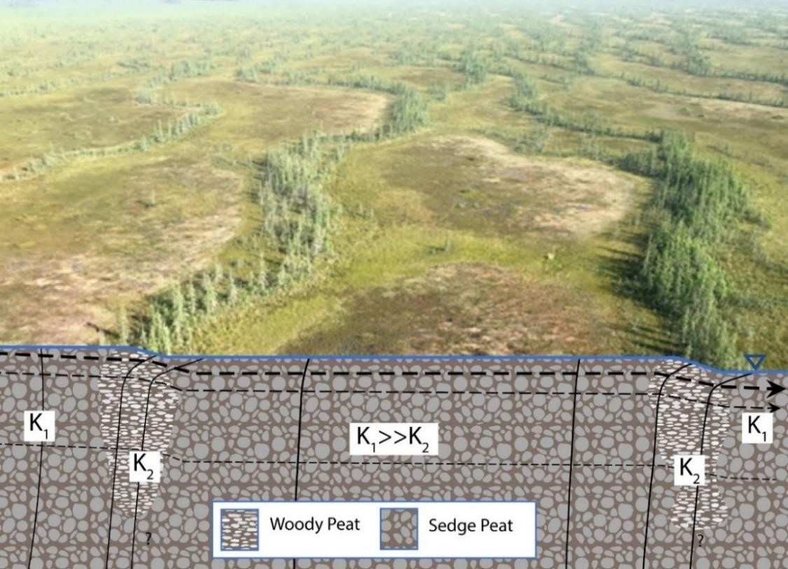
Figure 4 – Ridges (with trees) and flarks (open) in a moderate-rich fen. Peat stratigraphy and genesis (plant type) is distinct between ridges (woody, Sphagnum, and sedge) and flarks (sedge). Distinct peat in ridges may extend only part-way to the mineral substrate (Foster et al., 1988). Groundwater flow rates are controlled by ridges, which have lower hydraulic conductivity (K2) than flarks (K1), except perhaps in the upper ~10 cm as discussed in Section 4.2. Ridges impound flow, resulting in a stepped water table along the local hydraulic gradient. Flow is perpendicular to ridges, in this case left-to-right (dashed lines indicate flow, which is higher near the surface; vertical black lines are isopotential lines portraying contours of equal hydraulic head). In the foreground, ridge-spacing is approximately 40 m; in other fens, ridges can be much smaller and closer than shown here (Photograph by J. Price).