Box 2 – Permafrost Peatlands
The boreal and subarctic regions contain approximately half of the earth’s peatland area. In these regions, permafrost is typically discontinuous, with higher concentrations in low-lying terrains where peatlands predominate. In such terrains, permafrost is often restricted to below forested bogs known as peat plateaus that rise 1 to 2 m above permafrost free, often treeless, wetland terrain of collapse scar wetlands and channel fens (Figure Box 2-1). Unlike their surrounding wetlands, peat plateaus contain a well-developed vadose zone. Being a relatively dry layer, the vadose zone has a very low thermal conductivity, a property that enables it to thermally insulate and preserve the underlying permafrost, even in regions where the mean annual air temperature is close to or even above the freezing point.
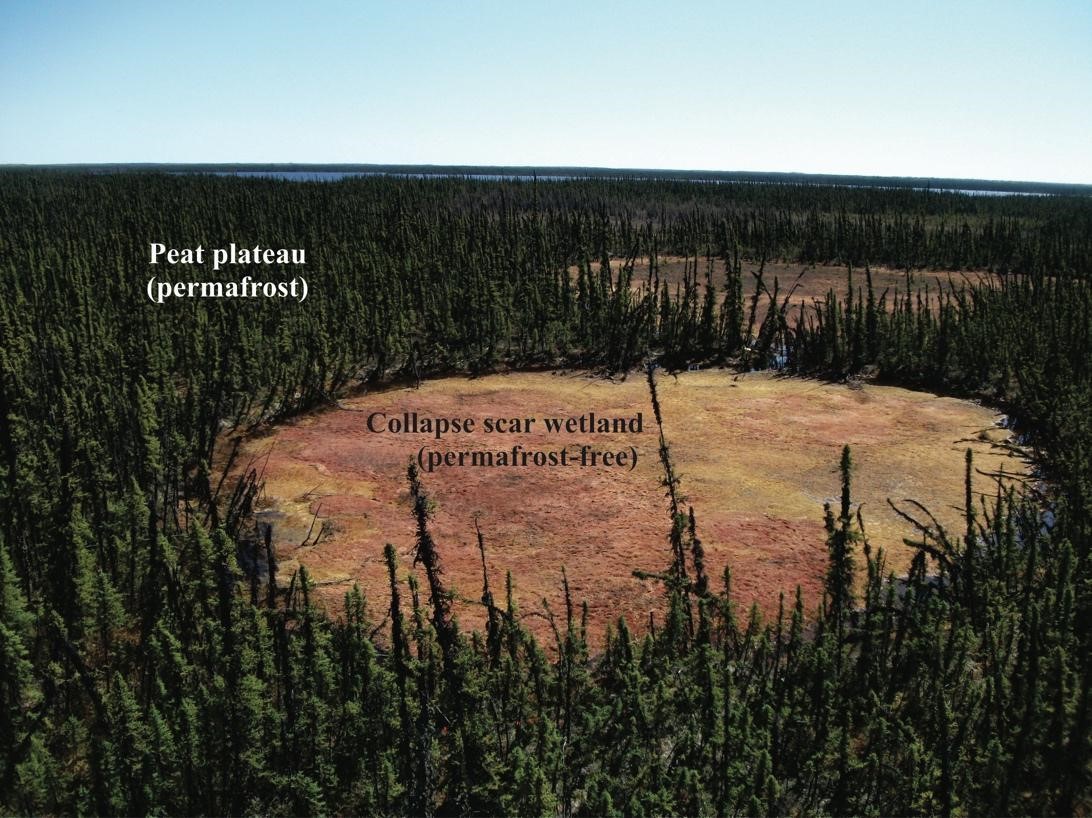
Figure Box 2-1 – Collapse scar wetlands (permafrost free) formed within a tree covered peat plateau. Scotty Creek, Northwest Territories, Canada. (Photograph by R. Connon)
Peat plateaus and collapse scar wetlands are typically arranged into distinct plateau wetland complexes separated by channel fens that collect the water draining from the complexes and convey it to the basin outlet. Because of their higher (1 to 2 m) topographic position, sloping surfaces, and the presence of relatively impermeable (ice-rich) permafrost near the ground surface, suprapermafrost (i.e., above the permafrost layer) groundwater drains either from the forested peat plateaus into the collapse scar wetlands or directly into the channel fens. The very high permeability of peat plateau surfaces precludes overland flow; as a result, drainage from plateaus is predominately through the saturated layer between the water table and underlying frost table.
The frost table is the base of this suprapermafrost groundwater flow zone because it is relatively impermeable, given that the underlying peat is frozen and saturated with ice and a small amount (< 15 percent of soil volume) of unfrozen water. The combined effect of the depth dependency of hydraulic conductivity and the nearly impermeable underlying frozen peat makes the degree of thaw of the seasonally frozen (active) layer a critical factor that controls the rate of subsurface runoff. Subsurface flow rates are high early in the thaw season since the frost table at that time is close to the ground surface; therefore, the overlying saturated layer occupies peat with high hydraulic conductivity values. Later in the thaw season, when the saturated layer is deeper in the peat, subsurface runoff rates are orders of magnitude lower.
Since the lateral flux rate of groundwater through the active layer in the case of permafrost peatlands—and through the thawed peat layer in the case of seasonally frozen peatlands—is closely coupled with the degree of ground thaw, groundwater flow from peatlands is closely coupled to the conduction of energy into the ground. The majority (> 85 percent) of the heat flux conducted vertically downward from the plateau ground surface into the peat profile is used to melt the ground ice (Hayashi et al., 2007). Owing to spatial variations of near surface soil moisture (i.e., wetter areas enable greater conduction of energy to the thawing frost table depth), the frost table depth can vary widely over short distances and therefore so too can the topography of the frost table.
Topographic variations of the frost table surface, including the slope of the frost table, control the rate and direction of groundwater flow. However, unlike the topography of other impermeable surfaces (e.g., bedrock), the frost table topography evolves when air temperatures are above 0 °C due to spatial and temporal variations of ground thaw. As a result, the rates and directions of subsurface flow from plateaus and from seasonally frozen peatlands often vary with time over the thaw season.
Peat plateaus are a type of bog that arises from the upward displacement of the ground surface resulting from the formation of permafrost. At the landscape scale over a period of decades to centuries, peat plateaus form within wetlands where interannual ice bulbs aggregate into permafrost bodies whose growth vertically displaces the overlying wetland terrain. This is followed by subsidence and collapse through a type of permafrost degradation called thermokarst erosion, a process that transforms tree-covered permafrost terrain (peat plateaus) back into treeless, permafrost free wetlands, known as collapse scars. Such erosion involves simultaneous permafrost thaw, ground surface subsidence, and inundation by adjacent wetlands. This process is an on-going and defining feature of the landscape type shown in Figure Box 2-2.
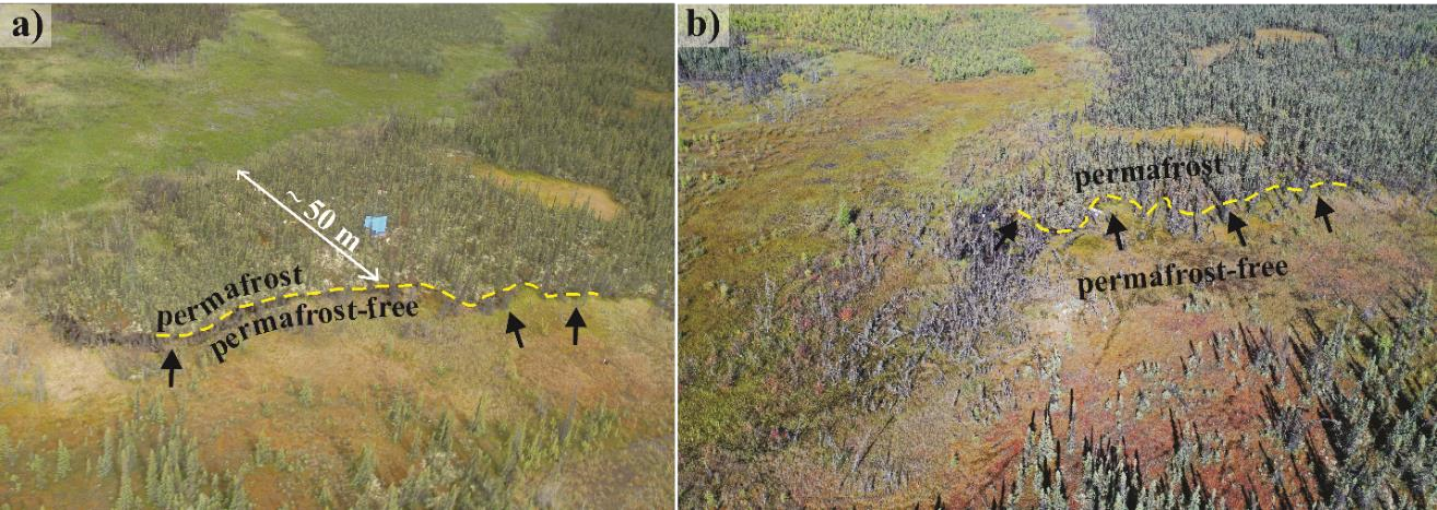
Figure Box 2-2 – Permafrost thaw-induced landcover change between a) 14 June, 2003, and b) 30 August, 2020, at Scotty Creek, Northwest Territories, Canada. The yellow, dashed lines indicate the boundary between permafrost (forested peat plateaus) and permafrost-free (treeless wetland) terrains. The black arrows indicate the direction of expansion of the permafrost-free terrain. (Photograph credits: (a) W. Quinton; (b) M. Dominico)
In a stable climate, thermokarst erosion is localized and does not result in a net loss of permafrost from a landscape since it is balanced by the re-establishment of permafrost below relatively dry areas of collapse scars, which over a period of decades to centuries can transition collapse scar wetlands back into peat plateaus. As such, the outcome of this process differs from that of climate-warming induced permafrost thaw since the latter results in a steady loss of permafrost terrain from a region.
The transformation of a forest underlain by permafrost to one that is permafrost free (Figure Box 2-3) is accomplished through a number of intermediate stages during which key processes (e.g., increased hydrological connectivity with the basin drainage network, partial wetland drainage, development of hummock topography, and tree seedling establishment) alter the ecohydrological environment and introduce new processes and feedbacks. The direction and relative importance of these and other processes and their associated feedbacks have not yet been quantified. The timescales of the transition are estimated to be less than half a century based on literature and observations of recent change captured by aerial/satellite imagery archives (Haynes et al., 2020). Ecohydrological modeling of the processes and associated feedbacks depicted in Figure Box 2-3 would greatly enhance the mechanistic understanding of this changing environment and its implication for peatland—groundwater interactions. This depiction identifies black spruce forest—either underlain by permafrost or permafrost free—as end members; that between these end-members is a wetland type defined as a transition wetland whose hydrological and ecological processes and properties evolve with time.
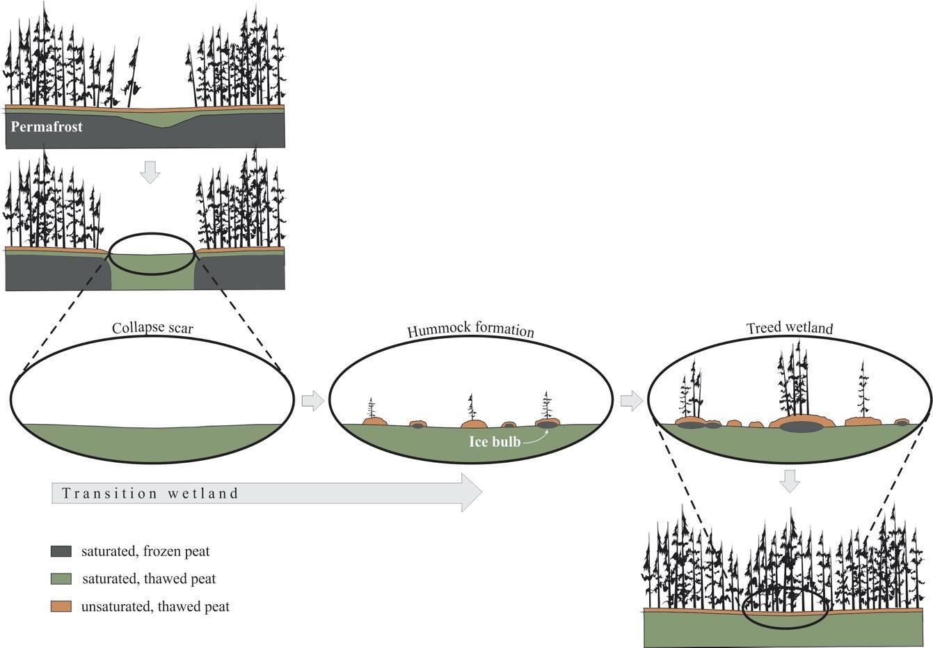
Figure Box 2-3 – Wetland transition following the permafrost thaw-induced development of a collapse scar wetland. Gray arrows indicate direct mechanisms and dashed lines represent potential feedbacks. Partial drainage of wetlands following the thaw of permafrost at their margins enables hummock development. Thermal insulation by the unsaturated surficial peat helps preserve seasonal ice bulbs that develop during winter due to greater exposure of hummocks to the atmosphere. The aerobic surfaces of hummocks promote re-establishment of black spruce, catalyzing the formation of treed wetlands, and ultimately the return of black spruce forests, although without permafrost (Modified from Haynes et al., 2020).