2.4 Bogs
Further accumulation of peat and the accompanying water table rise to an elevation at or above that in the adjacent mineral uplands (Figure 2), prohibits groundwater inflow from reaching the ground surface and plant rooting zone. In this case, the peatland transitions to a peatland exclusively fed by precipitation near its surface. Such raised peatlands are called bogs, at least in subarctic, boreal, and temperate zones.
Although succession to bog arising from peat accumulation is common, it is important to note that swamp and fen can be stable states and persist as such for millennia. Tropical peatlands can also become domed but given their predominantly woody vegetation they are referred to as swamps (Page et al., 2000). While local groundwater discharge from mineral sediments is absent in domed peatlands, regional groundwater discharge can, in some settings, periodically sustain the local water table (Siegel and Glaser, 1987). In northern regions, the formation of ground ice below peatlands or parts thereof can also raise the peatland surface above the surrounding terrain.
Bog peatlands are dominated by Sphagnum mosses, lichens, and herbs, along with small shrubs and stunted trees (Figure 5). Bogs are said to be ombrogenous, and thus ombrotrophic (“ombro” is derived from the Greek word for rain). The diminished minerotrophy favors a shift to acid-tolerant plants, especially Sphagnum mosses. Sphagnum mosses are more resistant to decay than most vascular plants and add to the vertical development of the emerging bog. Since Sphagnum releases organic acids, their presence further lowers the ambient pH. Van Breemen (1995) explains this in his wittily entitled article “How Sphagnum bogs down other plants.”
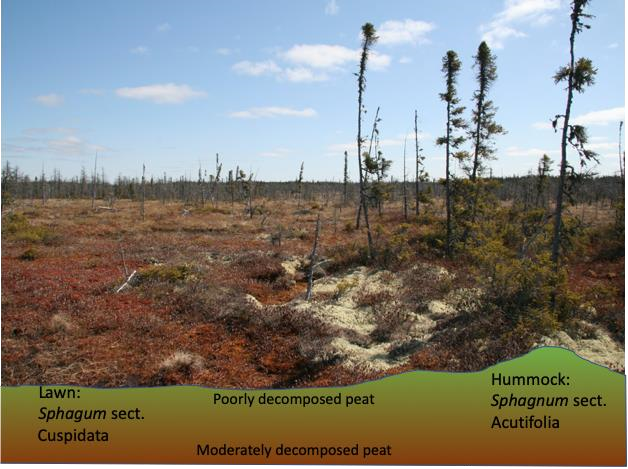
Figure 5 – Boreal bog dominated by Sphagnum mosses (left foreground) and stunted black spruce trees (right side and background), woody shrubs (right foreground), and sometimes lichen (bottom right). The dominant peat-forming plant is Sphagnum, which predominantly forms the groundwater matrix. Sphagnum mosses fall within different sections of the genus. Acutifolia species like S. fuscum and S. rubellum form relatively tight communities better adapted for being above the water table (better capillarity). Cuspidata species, like S. papilosum and S. angustifolium have looser growth forms and community structure and are situated closer to the water table. (Photograph by J. Price)
While bogs, by definition, are fed only by precipitation, they generally cannot be distinguished from fens with very weak groundwater inflow based on groundwater measurements. Rather, the distinction between bogs and poor fens is more commonly made on the basis of pH, calcium concentration, and presence/absence of obligate plant species such as Juncus spp. and Equisetum spp., which are characteristic of poor fens. Bogs generally have pH < 4 (Zoltai and Vitt, 1995).
In bogs, the rate of peat accumulation is greatest furthest from the peatland margins where Sphagnum is most likely to develop (Figure 2c). Near the peatland margins, mineral-rich water inhibits Sphagnum growth due to elevated concentrations of base cations, especially calcium. In the central peatland, the peat ground surface often rises to produce a peat dome, and such systems are often called domed, or raised bogs. The height of domed peatlands is discussed in Box 1. In domed tropical peatlands the ultimate shape is first reached near boundaries (i.e., rivers) while carbon storage inland progresses at a rate proportional to the remaining interior area (Cobb et al., 2017). At the margin of a raised bog, a moat-like lagg can develop where groundwater discharge from both the bog and the adjacent mineral terrain converges.
Where groundwater discharge is relatively high, laggs are hydrologically, biogeochemically, and ecologically distinct (Figure 6). Where there is lower discharge, or where discharge from bogs continues landward (toward the mineral terrain), the laggs are less defined or even absent (Langlois et al., 2015, 2017; Howie and Tromp-van Meerveld, 2011). Laggs collect water and convey it laterally (i.e., into or out of the page in Figure 6), and thus can be an important feature that enhances peatland connectivity to surface water systems. The absence of the modulating effect of groundwater input to bogs (notwithstanding potential regional effects as noted earlier) typically results in a deeper and more variable water table than in fens; it is by nature more episodic, and commonly reaches 35 to 50 cm bgs (Figure 3). It is important to record the datum used for measurement of the water table when there is distinct microtopography that varies with time, such as in bogs. The water table depth is much greater beneath the hummocks than the hollows.
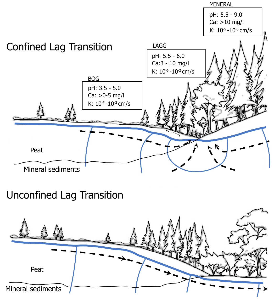
Figure 6 – Conceptual diagram of laggs, which occur at the margin of bogs. The thick blue line is the water table, while thin blue lines represent isopotentials. In the upper diagram, groundwater flow (black dashed lines) from the bog and adjacent mineral terrain converge to form a distinct lagg (confined lagg). In the lower diagram, where groundwater flow is unidirectional, a less distinct feature forms (unconfined lagg). In both cases, the groundwater chemistry is a mix of water from organic and mineral terrains (Modified from Howie and Tromp van Meerveld, 2011).
The hydrological function of bogs in the broader landscape is to store and periodically shed water. Peat can contribute groundwater to underlying mineral deposits, but this is generally minor due to the low vertical hydraulic conductivity associated with most basal peats and underlying mineral sediments. Bogs are unlikely to exist in a setting with high recharge or steep slopes, because excessive water loss would result in conditions too dry for a bog to form. However, in certain locations, including those with hyper-maritime climates with persistent rainfall and cool, foggy conditions, blanket bogs can form on undulating ground with slopes up to 15° (Chico et al., 2020). Blanket bogs are most common in northern latitudes, including northern parts of Europe and North America, but are also present in Patagonia, New Zealand, and the Falkland Islands.