2.5 Groundwater Quality
Groundwater quality in the mega aquifer systems can be viewed from different angles: natural or geogenic quality on the one hand, and groundwater quality as modified (usually polluted) by anthropogenic factors on the other. Below, a few aspects of groundwater quality in the mega aquifers systems are briefly reviewed. The main purpose is to provide an impression of the macro-variation of important water quality parameters that determine the suitability of these groundwater resources for human uses, such as domestic and irrigation water use.
2.5.1 Groundwater Salinity
The total concentration of dissolved solids or salts (TDS, expressed in mg/L or ppm) is a widely used water quality indicator. Commonly, three main classes are distinguished: fresh, brackish and saline water. Saline water is sometimes subdivided into subclasses like slightly to moderately saline, highly saline and hypersaline. The class limits are not rigorously standardized. The level of 1000 mg/L of dissolved solids is usually adopted as the limit between fresh and brackish water, but some sources prefer the stricter limit of 500 mg/L. Likewise diverging are the concentrations adopted for distinguishing between brackish and saline water: these values range from 3,000 to 10,000 mg/L (the latter is most commonly adopted). Hypersaline water (brine) has a significantly higher salt concentration than ordinary seawater (35 g/L, on average). Many publications dealing with brackish or saline groundwater do not specify the adopted class limits.
Most human water uses require or prefer freshwater. Although the mega aquifer systems contain fresh groundwater in abundance, significant quantities of brackish and/or saline groundwater are also present in virtually all of them. The occurrence of saline or brackish groundwater resulting from natural processes is briefly outlined in Box 2 for the majority of the mega aquifer systems, mainly based on papers and reports accessible on the internet. The information reviewed for these aquifer systems confirms the general idea that the upper parts of the aquifer systems (usually hydrologically dynamic) tend to contain fresh groundwater, while the probability of high mineralization levels increases with depth and is higher for low-permeability formations (aquitards) than for permeable ones (aquifers). Nevertheless, exceptions to this generalized pattern do occur, as pointed out by Van Weert and others (2009) and by Van Weert and Van der Gun (2012), among others. Examples of mega aquifer systems where saline or brackish groundwater is predominant at shallow depths are the Ogaden-Juba Basin, the Stampriet-Lower Kalahari Basin, the Northern Great Plains Aquifer System, the Arabian Aquifer System and the Great Artesian Basin (Box 2).
Quite a few different origins of groundwater salinity have been identified: both marine and terrestrial ones, the latter either natural or anthropogenic. Important genetic types of marine origin are connate saline water (entrapped in marine sedimentary formations) and saline water intruded into formations during marine transgressions or during incidental flooding by the sea (such as caused by tsunamis or spring tides). Such saline waters (often paleowater) are observed in many of the mega aquifer systems (e.g., in the northern confined part of the Nubian Aquifer System, the southern part of the Iullemeden-Irhazer Aquifer System, the southern part of the Ogaden-Juba Basin, the Gulf and Atlantic Coastal Aquifer System, the Senegalo-Mauritanian Basin and the North China Plain Aquifer System). Lateral intrusion of seawater, caused by differences in density between seawater and fresh groundwater, may occur where aquifers border the sea. Since most of the mega aquifer systems are continental, this is only relevant for a few of them, in particular the Nubian Aquifer System, the Senegalo-Mauritanian Aquifer System, the Gulf and Atlantic Coastal Aquifer System, the Indus and Ganges-Brahmaputra Basins and the North China Plain Aquifer System. Intensive groundwater abstraction in the coastal zones has triggered and intensified seawater intrusion in several aquifers (e.g., the Biscayne aquifer in Southern Florida, the Nile Delta aquifers, and the coastal aquifers of the Senegalo-Mauritanian Basin).
Groundwater salinity of various natural terrestrial origins is observed in many of the mega aquifer systems. Evaporites play an important role. They have been formed throughout geological history; the chotts of North Africa, the sabkhas of the Arabian Peninsula and the playas in the Americas testify that such processes continue today. Dissolution of salts from evaporites (or other naturally occurring soluble minerals) and their subsequent migration by groundwater flow is a major source of groundwater salinity in the Northern Great Plains, the Cambrian Ordovician Aquifer System and the eastern part of the Arabian Aquifer System. More or less contemporaneous salinization of shallow groundwater may take place by evaporation from a shallow water table or stagnant surface water bodies under endorheic conditions. This is observed in the Nubian Aquifer System (Natrun and Qattara depressions), the North-Western Sahara Aquifer System (Chott el Djerid and other chotts along the northern boundary), the topographically lower part of the Lake Chad Basin (around Lake Chad), and the central part of the Sudd Basin.
Finally, the salinity level of groundwater may also increase as a result of human activities. Apart from the intensification of seawater intrusion by groundwater abstraction in the coastal zone (enhanced by sea-level rise), this category includes in particular the gradual increase of shallow groundwater salinity by irrigation return flow. Large areas may become salinized in this way, for instance in the Central Valley and High Plains of the USA, in the lower part of the Indus Basin, in the zone where the Indus and Gangetic-Brahmaputra basins meet (Haryana and Punjab) and on the North China Plain (FAO, 2011). Numerous other human activities cause an increase in groundwater salinity, often with harmful local impact, but the affected areas usually are a small fraction of the total horizontal extent of the mega aquifer systems.
2.5.2 Arsenic and Fluoride
Arsenic (As) is one of the geogenic contaminants that can cause severe health problems to humans (cancer and non-cancerous disorders) if present in water in relatively high concentrations (Nordstrom and Smedley, 2022). The WHO provisional guideline for drinking water currently allows a maximum value of 10 μg/L (Smedley, 2008). Although the presence of arsenic in concentrations exceeding this limit has been observed in many parts of the world, only a few of the 37 mega aquifer systems have extensive zones of high-arsenic groundwater. Most notable is the widespread arsenic pollution in shallow groundwater throughout the floodplains of the Bengal Basin, located in the eastern part of the Ganges-Brahmaputra Basin (MacDonald et al., 2015 and 2016). Since the 1980s, millions of people there have suffered from arsenic poisoning by drinking this water that commonly contains arsenic in concentrations between 10 and 1000 μg/L. As shown in Figure 12, large zones of high levels of arsenic in shallow groundwater are also present in other parts of the Ganges Brahmaputra Basin and the adjoining Indus Basin.
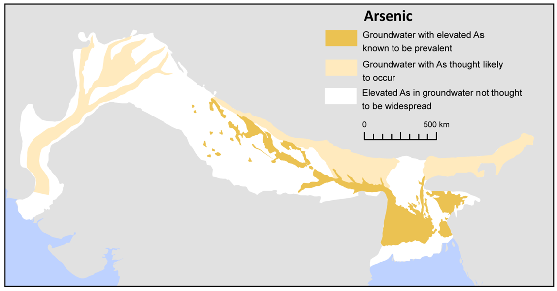
Figure 12 – Known or expected levels of arsenic in shallow groundwater in the Indus-Ganges-Brahmaputra Aquifer System (MacDonald et al., 2015; reproduced with permission of BGS © UKRI http://nora.nerc.ac.uk/id/eprint/511898/).
Other mega aquifer systems where zones of excessive arsenic levels are known to be present are the High Plains Aquifer and California’s Central Valley; where 9 percent and 8 percent, respectively, of the wells sampled in a national groundwater quality survey, showed arsenic contents exceeding the WHO limit in those areas (DeSimone et al., 2014).
A second important geogenic contaminant is fluoride (F). Continued consumption of high-fluoride water may cause dental fluorosis and in extreme cases even skeletal fluorosis (Feenstra et al., 2007; Edmunds and Smedley, 2013). A fluoride concentration below 1.5 mg/L is commonly considered safe for potable water. Global hotspot zones of excessive fluoride in groundwater have been mapped by Edmunds and Smedley (2013). Some of these are located inside the boundaries of the mega aquifer systems: zones in central-western Senegal (Senegalo-Mauritanian Basin), at selected locations in Algeria, Libya, Egypt and Sudan (NWSAS and NAS) as well as in Uttar Pradesh (Ganges-Brahmaputra Basin), and zones in the middle and lower Indus Basin (IAEA, 2017a; Edmunds and Smedley, 2013). Other sources (Kut et al., 2016; GWP, 2013; Woodford and Chevallier, 2002; GGRETA, 2016) also mention excessive fluoride levels in groundwater of northern and central Somalia (Ogaden-Juba Basin), the Tchad Basin, the South African Karoo Basin, the Stampriet Basin (especially the Nossab aquifer) and in some places of the North China Plain Aquifer System.
In addition, Nordstrom and Smedley (2022) presented a literature review demonstrating increased interest in fluoride contamination worldwide within the scientific literature. Their analysis included data for 85 countries, demonstrating that in recent decades the number of publications almost doubled. They mention that there are well over 1000 reports on the subject from China and India combined.
2.5.3 Anthropogenic Groundwater Pollution
The causes and mechanisms of anthropogenic groundwater pollution are numerous, and there is a large diversity of pollutants. Households, industries, mining and agriculture produce enormous quantities of waste and wastewater. Fetter (1993) distinguished six categories of sources of anthropogenic groundwater contamination:
- sources designed to discharge substances (septic tanks, injection wells, land application of wastewater);
- sources designed to store, treat and/or dispose of substances (landfills, open dumps, residential disposal, surface impoundments, mining waste and stockpiles, graveyards, storage tanks, incineration and detonation sites, radioactive waste disposal sites);
- sources to retain substances during transport (pipelines, trucks and trains);
- sources discharging substances as a consequence of other planned activities (irrigation, use of pesticides and fertilizers, farm animal wastes, road salting, percolation of atmospheric pollutants, mine drainage, etc.);
- sources providing a conduit for contaminated water to enter aquifers (wells, construction excavations); and,
- naturally occurring sources whose discharge is created or acerbated by human activity (interaction with polluted surface water, natural leaching enhanced by acid rain, saltwater intrusion).
It is beyond the scope of this section to go into details, but a few comments can be made on the risk of anthropogenic groundwater pollution. This risk on one hand depends on aquifer system properties (in particular its vulnerability to pollution) and, on the other hand, on human presence and activities. It is likely positively correlated with the mean population density in the corresponding area. In this regard, three mega aquifer systems belong to the high-density category (300 to 1000 persons per km2): the North China Plain, the Ganges-Brahmaputra Basin and the Indus Basin, while three are in the moderately-high population density category (100 to 300 persons per km2): the Paris Basin, the Atlantic and Gulf Coastal Aquifer System, and the Central Valley of California. In contrast, the mean population density of several other mega aquifer systems – such as the Amazon basin, the North-Russian basins and the two Australian mega aquifer systems – is very low (less than 10 persons per km2).
Furthermore, intensive agriculture (often in combination with irrigation) increases the groundwater pollution risk. This is the case in mentioned areas of the North China Plain, the Ganges-Brahmaputra Basin, the Indus Basin, California’s Central Valley and the Paris Basin, but also on the sparsely populated High Plains. Anthropogenic pollution is high throughout the area of the systems with very high population density but tends to be limited to minor parts of the area of most mega aquifer systems of sparse to moderately-high population density because they are so large.
Finally, it should be pointed out that the deeper parts of the sedimentary basins are target zones for oil and gas development, geothermal energy recovery and permanent storage of hazardous substances. Information on these potentially polluting activities is only scarcely and fragmentarily available in the public domain.