2.4 Recoverable Volumes of Stored Groundwater: Groundwater Reserves
2.4.1 Total Stored Volume Versus Groundwater Reserves
Before focusing on the recoverable volumes of groundwater stored in the mega aquifer systems, it is useful to give some thought to what is meant by the term ‘volume of stored groundwater. The most obvious interpretation is that this includes all water present in the interstices of the saturated rock formations in the area or aquifer system concerned. In its most simple form: the volume of groundwater storage equals the bulk volume of saturated rock times mean porosity. Although usually not explicitly mentioned, this seems to be the idea underlying the various estimates of the global volume of groundwater made since the 1960s (e.g., Nace, 1969; NRC, 1986; Shiklomanov and Rodda, 2003; Margat and Van der Gun, 2013; Gleeson et al., 2016). These estimates are no more than educated guesses, based on generic assumptions about the subsurface rather than on area-specific geological data and information, but they have contributed to a widely accepted belief among the global groundwater community that the total volume of groundwater on Earth is approximately 23 million km3, of which between 8 and 9 million km3 is fresh.
However, one should be aware that a considerable share of all groundwater cannot be abstracted by wells, nor drained under gravity, due to matrix forces that keep a fraction of the water trapped in the pores of saturated formations (represented by the parameter specific retention). These matrix forces are particularly strong and effective in fine-grained formations such as clays and shales that form aquitards. For this reason, more relevant than the total volume of groundwater is the ‘theoretically recoverable groundwater volume’ (or ‘groundwater reserves’), which is calculated as the product of the bulk volume of saturated rock and its specific yield. Estimates of stored groundwater volumes made in the framework of regional or aquifer-specific studies commonly are based on this interpretation of groundwater storage; although often not explicitly mentioned, this can usually be concluded from the text or data presented in the report or paper. When producing their estimates for aquifer systems that contain both aquifers and aquitards, hydrogeologists usually disregard the aquitards, since their contribution to the total theoretically recoverable volume of groundwater is minimal. Permafrost in several of the Russian mega aquifer systems creates special conditions that significantly reduce the aquifer volume occupied by drainable groundwater, as illustrated in Box 1. In practice, only a minor part of the groundwater reserves is available for exploitation, due to technical, financial and water quality constraints as well as the need to avoid undesired side effects such as land subsidence and harmful impacts on surface water and aquatic ecosystems (Alley, 2007).
2.4.2 Assessing Groundwater Reserves
The volume of recoverable groundwater stored in the mega aquifer systems is difficult to assess, given the vast extent and considerable thickness of the systems. Nevertheless, several scientists attempted to do so. For instance, MacDonald and others (2012) have mapped groundwater storage in Africa, based on their assessment of saturated aquifer thickness and effective porosity (Figure 11). The African mega aquifer systems are visible on this map. The authors estimate total recoverable groundwater storage in Africa to be 0.66 million km3, and the greatest mean equivalent water depths (> 25 m) are found in the Nubian Aquifer System, the North-Western Sahara Aquifer System, the Murzuk-Djado Basin, the Senegalo-Mauritanian Basin and the Lower Kalahari-Stampriet Basin. Richey and others (2015a) estimated recoverable groundwater storage for all 37 mega aquifer systems considered in this book, but their estimates seem to be poorly underpinned by geological data and they are presented for each aquifer system in the form of minimum and maximum values that differ mostly by two orders of magnitude. Therefore, for a closer look at groundwater reserves, the focus here will be on estimates produced by hydrogeologists investigating individual mega aquifer systems and assumed to be familiar with the geology of these systems.
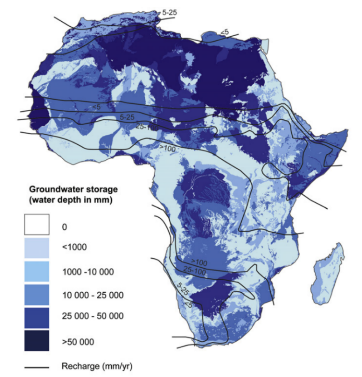
Figure 11 – Estimated equivalent depth of recoverable water stored in Africa’s aquifers (MacDonald et al., 2012).
Groundwater assessments of aquifers and aquifer systems only rarely include estimates of recoverable groundwater storage. Consequently, reports and publications presenting such estimates are not abundant, and therefore estimates of recoverable groundwater storage have only been found for approximately half of the mega aquifer systems, in some cases including only parts of these systems. These estimates are presented in Table 6, expressed in thousands of cubic kilometers (third column), and – to facilitate comparison and analysis – converted (in the fourth column) to an equivalent mean depth of water over the entire horizontal area occupied by the aquifer system. Although detailed explanations are missing in the majority of the publications, it is assumed that all estimates refer to fresh groundwater reserves stored in aquifers.
Table 6 – Estimates of theoretically recoverable groundwater storage (‘groundwater reserves’) for selected mega aquifer systems (or parts of these systems).
| # | Aquifer System | Groundwater storage | Source | Comments | |
| 103 km3 | Equivalent depth (m) | ||||
| 1 | Nubian Aquifer System (NSAS) | 457 | 208 | Bakhbakhi, 2006 | Only fresh groundwater (saline water = 68 m) |
| 542 | 247 | Salem, 2005 | Only fresh groundwater | ||
| 500 | 227 | OSS, 2020 | |||
| 2 | NW Sahara (NWSAS) | 31 | 30 | Baba Sy, 2010 | |
| 60 | 59 | Zektser & Everett, 2004; OSS, 2020 | |||
| 3 | Murzuk-Djado Basin | 4.8 | 11 | Salem, 2005; OSS, 2020 | |
| 4 | Taoudeni-Tanezrouft | 10 | 3.0 | OSS, 2020 | |
| 5 | Senegalo-Mauritanian | 9 – 10 | 30 – 33 | Diagana, 2005b | |
| 1.5 | 5.0 | OSS, 2020 | |||
| 6 | Iullemeden-Irhazer | 4.95 | 7.8 | Baba Sy, 2010; OSS, 2020 | |
| 7 | Lake Chad Basin | 5.8 | 3.0 | OSS, 2020 | |
| 8 | Sudd Basin | 11.5 | 32 | RSS, 2015 | Area 432,700 km2 |
| 16 | Central Valley | 0.86 | 16.5 | Scanlon et al., 2012 | Predevelopment (1860s): 1000 km3 (19.2 m) |
| 1.02 | 19.6 | Kang & Jackson, 2016 | Fresh in upper 1000 m (TDS < 3000 ppm) | ||
| 2.7 | 51.9 | Kang & Jackson, 2016 | Fresh down to 3000 m (TDS < 3000 ppm) | ||
| 17 | High Plains | 3.67 | 8.2 | Scanlon et al., 2012 | Predevelopment (1950s): 4000 km3 (8.9 m) |
| 19 | Amazon Basin | 32.5 | 21.7 | Rebouças, 1999 | Only Cenozoic strata |
| 20 | Maranhão Basin | 17.5 | 25.0 | Rebouças, 1999 | |
| 21 | Guarani Basin | 40 | 33.5 | Tujchneider et al., 2010 | |
| 30 | 25.2 | Hirata & Foster, 2020 | |||
| 22 | Arabian Aquifer System | 253 | 171 | Chowdhury & Zahrani, 2013; Frenken, 2009 | Water Atlas of Saudi Arabia (only share of Saudi Arabia) |
| 338 | 228 | Chowdhury & Zahrani, 2013; Frenken, 2009 | Ministry of Planning SAU (only share of Saudi Arabia) | ||
| 23 | Indus Basin | 10.4 | 33 | MacDonald et al., 2012 | Only upper 200 m of 3000 m of sediments |
| 24 | Ganges-Brahmaputra Basin | 19.6 | 33 | MacDonald et al., 2012 | Only upper 200 m of 3000 m of sediments |
| 29 | Greater N. China Plain | 3.96 | 29 | Cao et al., 2013 | Only Hai Plain (136,000 km2) |
| 32 | Paris Basin | > 0.68 | > 3.6 | König, 2015 & LeCompa, 2010 | Only Lower Cretaceous Albien (425 km3) and Néocomien (230 km3), plus Tertiary Nappe de Beauce (20 km3) |
| 0.70 | 4.0 | SIGES, 2021 | Albien and Néocomien | ||
| 36 | Great Artesian Basin | 87 | 51 | Habermehl, no date | Earliest estimate |
| 64.9 | 38 | Hillier & Foster, 2002 | |||
2.4.3 Comparison and Analysis of the Estimates of Groundwater Reserves
Purposefully, Table 6 shows alternative estimates for several of the aquifer systems. This is done not only to avoid choosing between alternatives without careful analysis but more to emphasize that the estimates are subject to a large degree of uncertainty, caused by the scarcity of geological data and the unavoidable subjectivity of their hydrogeological interpretation. Despite the uncertainties, the set of estimates suggests that most of the mega aquifer systems have groundwater reserves equivalent to a mean depth of water of tens to hundreds of meters. The area-weighted average equivalent thickness for all the mega aquifer systems is 69 m. That value would certainly have been 10 to 20 percent more if the total thickness of the Amazon, Indus and Ganges-Brahmaputra basins had been included in the table.
By extrapolation one may estimate that the groundwater reserves of the 37 mega aquifer systems together are between 2 and 3 million km3. Among the mega aquifer systems listed in Table 6, the largest reserves are present in order of their magnitude in the:
- Nubian Aquifer System;
- Arabian Aquifer System;
- Great Artesian Basin;
- North-Western Sahara Aquifer System;
- Guaraní Basin;
and if the entire sedimentary sequences are taken into account, they are probably followed by the:
- Amazon Basin;
- Indus Basin; and,
- Ganges-Brahmaputra Basin.
Among the aquifer systems that are not listed, most likely the Russian Platform Basins and the West-Siberian Basin contain huge reserves, given their enormous extent and large thickness of accumulated porous sediments. Nevertheless, the fresh groundwater reserves of the latter may be much smaller than expected at first glance, because large parts of the aquifer interstices are filled with ice (as discussed in Box 1) or saline water (Foley et al, 1994).
What share of the total groundwater reserves of the world’s continents is stored in the 37 mega aquifer systems? This question is difficult to answer in the absence of reliable data on the total volume of theoretically recoverable groundwater on earth. Nevertheless, an educated guess can be made by using the Groundwater Resources Map prepared by WYMAP (WHYMAP, 2008; Richts et al., 2011). This map divides the earth’s land area (excluding Antarctica) based on groundwater occurrence into three main classes: major groundwater basins (35%), areas with complex hydrogeological structure (18%) and areas with only local and shallow aquifers (47%). Assuming the mean theoretically recoverable groundwater volume per square kilometer for the first class to be equal to that of the mega aquifers (which is probably an overestimate), and for the second and third classes to be 20% and 1% of that value, respectively, leads to the estimate that the 37 mega aquifer systems contain 64% of the world’s total fresh groundwater reserves. As mentioned before, this percentage is only an educated guess and thus subject to a large margin of uncertainty, but it is plausible to conclude that the 37 mega aquifer systems contain more than half of the world’s fresh groundwater reserves, perhaps even two-thirds. It is useful to note that offshore fresh groundwater has not been taken into account in this analysis.
2.4.4 Age of Stored Groundwater
The volume of groundwater reserves in these mega aquifer systems exceeds the annual recharge volumes by several orders of magnitude, as will follow from comparing the above-presented estimates with recharge estimates in Section 3.1. This implies that the age of groundwater (i.e., the time elapsed since it entered the aquifer system) varies enormously within each aquifer system; in particular, water may be very old in zones of stagnant water and zones where groundwater has already traveled over long flow paths. Indeed, groundwater investigations using environmental isotope techniques have confirmed the presence of very old groundwater in certain zones of large aquifers systems, in combination with rather young water elsewhere within the same systems (Matray and Chery, 1998; Thorweihe and Heinl, 2002; IAEA, 2017a). As reported by Voss and Soliman (2014), groundwater below oases in Egypt has been interpreted to be on the order of 1 million years old. As can be expected based on hydrological and hydraulic considerations, the youngest waters tend to be dominant at shallow depths while groundwater ages statistically increase with depth. Jasechko and others (2017) established – based on groundwater carbon isotope data from thousands of wells in 62 aquifers around the globe – the predominance of modern water at shallow depths and demonstrated that below a certain depth (varying from 50 to 550 m) the majority of the wells in each of these aquifers are dominated by groundwater older than 15,000 years.