8.4 Groundwater
8.4.1 Natural Groundwater Sources: Springs and Seeps
Natural sampling points for groundwater are most easily sampled. If totally natural, then the water is taken directly from the source (Figure 45). For springs (particularly hot springs) that have been capped or developed into resorts, it is best to sample as close to the source as possible. This may require finding the inlet to a hot pool, which is often an enjoyable sampling experience!
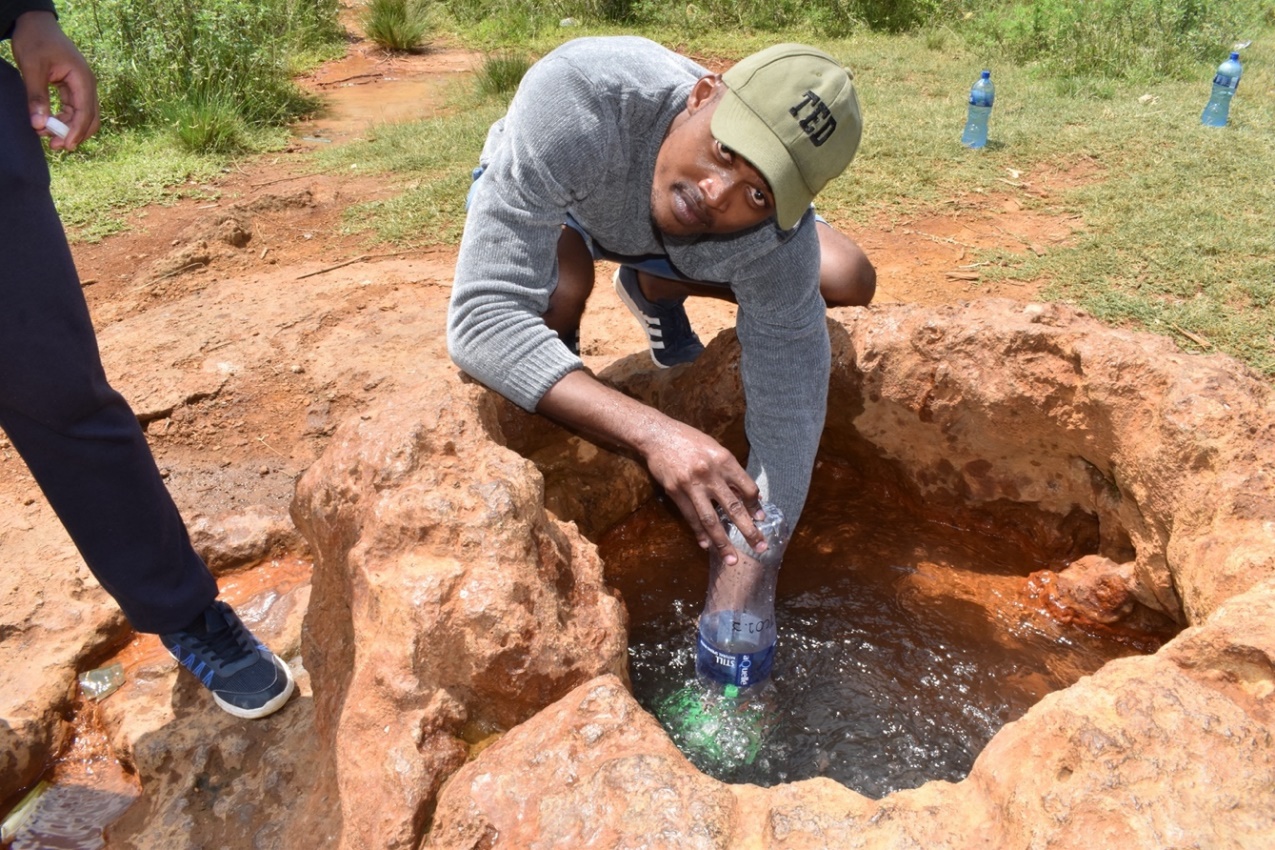
Figure 45 – Sibusiso Mbonani sampling gas from a CO2-rich cold-water spring near the uMtamvuna River on the Bongwana Fault, kwaZulu-Natal, South Africa. The water is sampled easily, but the gas is collected by first filling the sample bottle with water, then inverting it and capturing enough gas to fully displace all water and then sealing the bottle whilst still underwater. Stable isotopes of the CO2 suggest dissolution of carbonate rocks at depth as the source of CO2 (Harris et al., 1997), but more work remains to be done on the groundwater source and flow path.
8.4.2 Artificial Groundwater Sampling Points: Wells, Boreholes and Piezometers
Purging
Depending on the borehole construction and groundwater flow regime, groundwater may pass through the borehole casing and be relatively fresh, or it may not be part of the active flow system and become stagnant. If this condition is known, sampling procedures can be adjusted, but in many cases, the flow regime and in particular, the borehole construction, are not known. It is therefore advisable, to always purge a borehole before sampling.
Borehole purging requires removing enough water from the borehole to provide a fresh sample of water from the aquifer, which is representative of the natural groundwater. The rule of thumb is to purge 3 times the borehole volume before sampling. Calculating this value requires knowledge of the borehole diameter (this is usually the same as that seen at surface but may decrease with depth) and the height of the water column in the borehole. This height is the difference between the water level and the bottom of the borehole. Unfortunately, in many cases the depth of the borehole is not known. If this is the case, and the bottom cannot be sounded, then a rough guess can be made based on nearby boreholes in the aquifer being targeted to estimate the number of liters stored in the borehole and therefore, how much purging must be done.
In other cases, boreholes are equipped with pumps and the owner refuses to move these, and one has little idea of the water level and borehole depth. In this case, again, it is best to estimate values to calculate the volume to be purged. On the other hand, in many of these equipped boreholes, the groundwater is being pumped frequently and so a full purge is not as essential as in a research borehole that may have been standing unpumped for months or years.
If one has a thermometer, or other field probes, then these can also be used to determine when fresh aquifer water is being pumped because such readings should stabilize after sufficient purging. With temperature probes, it is useful to be aware of the difference between the air temperature (at which the probe will start reading) and the groundwater temperature. It may seem the groundwater is changing temperature rapidly at first, but that is the probe adjusting to the groundwater temperature.
Groundwater Heterogeneity
Groundwater is often assumed to be well mixed such that one sample will be representative of an aquifer. This is not always the case, and various investigations have discovered heterogeneity on a scale from centimeters upwards. Pollutants are well known to be heterogeneously distributed due to point source releases, accumulation near the water table, or other factors (Lasagna and De Luca, 2016; Ronen et al., 1987), but natural water quality parameters also vary substantially, even when the aquifer matrix appears relatively homogenous (Baloyi and Diamond, 2019; Petrella and Celico, 2012). The causes of these differences are complex and beyond the discussion here. However, it is important to understand how well a sample, or set of samples, represents the aquifer, bearing in mind issues such as heterogeneity. For example, a single sample may contain water that is not representative because of the variation from place to place, including materials and conditions between boreholes, or vertically within one borehole. This sample is not representative of the aquifer because it only characterizes one of the various water types present. On the other hand, the process of sampling, especially pumping at high rates from a borehole open to, or screened in, a large interval of the aquifer, can mix water from different levels that may have quite distinct compositions. This sample is not representative because it averages some or all of the water types present. For some investigations, often for regional studies, these sampling errors may not be an issue, but for others, such as characterizing contamination at a site, isolating discrete intervals and sampling them to preserve the natural heterogeneity is important. Technology to sample discrete horizons has been developed in more recent years (Cherry et al., 2007).
From a stable isotope perspective, many of the variations in water chemistry may not be accompanied by related changes in stable isotope composition. However, some hydrochemical changes may be associated with stable isotope changes, such as evaporation prior to recharge causing an increase in salinity, and an associated increase in values. Leaking water mains (or sewers) with hydrochemistry (or pollution levels) different from that of the local groundwater, may or may not reflect in the stable isotopes, depending on the source of municipal water relative to the source of local groundwater. Petrella and Celico (2012) mapped stable isotopes from the water table downward in a carbonate aquifer in Italy and found the upper 12 m or so to contain varied compositions, while below that the groundwater was better mixed. They concluded the level at which mixing is achieved depends upon the physical nature of the aquifer as well as the hydraulic conditions, for example the precipitation history and water level fluctuations.