1.4 Groundwater from Hard Rocks has a Major Role for Water Supply
A simplified map of global groundwater resources (Figure 5) shows the distribution of three major aquifer types. The tan areas of generally low permeability correspond to typical fractured aquifers formed of relatively old, fractured, crystalline rocks. The green areas represent complex aquifers with both intergranular and fracture porosity. The blue areas contain major regional aquifers composed of sedimentary rocks having significant intergranular porosity, as well as old volcanic rocks and low-permeability sedimentary rocks where flow is controlled by fracture porosity. Fracture flow is important in most bedrock aquifers, from rocks with low primary permeability to major regional aquifer systems.

Figure 5 – Simplified map of the three major types of global aquifers (after Whymap.org). The tan (yellowish) areas consist of rocks of generally low primary permeability and are typically fractured aquifers. Location indicators highlight three regions discussed in the text with strong dependence on fractured aquifers for water supply: a red marker for the Metropolitan Region of São Paulo, Brazil, a purple marker for the dry climate region in northeastern Brazil and an orange marker for sub-Saharan, western Africa.
Asia’s aquifers are mostly low primary permeability rocks. Fractured hard rock aquifers such as granite, gneiss, metamorphic rocks, and basaltic lava flows occupy 67 percent of India’s territory, and they outcrop in vast areas across the African continent (Zektser & Everett, 2004). Many of the highly populated areas in India are underlain by hard, fractured-rock aquifers, and the groundwater available from these rocks is the only source of water supply for the basic needs of millions of people (Zektser & Everett, 2004). Vast areas of South America, mostly in Brazil, are underlain by Precambrian crystalline basement rocks.
Figure 5 shows the location of three examples of regions that have a significant or strong dependence on fractured aquifers for water supply, namely, the Metropolitan Region of São Paulo (Figure 6), the northeastern region of Brazil (Figure 7) and sub-Saharan Africa (Figure 8). The Metropolitan Region of São Paulo in southeastern Brazil is inhabited by about 22 million people; its central portion lies on a sedimentary basin and the densely urbanized area has been, for some decades, expanding over fractured aquifers of crystalline Precambrian rocks. Public water supply is provided by surface water reservoirs, although thousands (around 12,000) of mostly private wells complement the water needs. Even though the water supply crisis caused by the 2013–2015 drought emphasized the importance of groundwater resources in meeting supply demands, contamination of shallow and deep aquifers (sedimentary and crystalline rocks, respectively) in large industrial areas has resulted in the shutdown of numerous wells and threatens public health and water security.

Figure 6 – Metropolitan Region of São Paulo Brazil (delimited by the red contour line): 22 million inhabitants in a very dense urbanized area (yellow and orange areas) that is expanding over crystalline Precambrian rocks (image from ArcGis, geological map from Riccomini & Coimbra, 1992).
The arid northeastern region of Brazil (Figure 7) covers 1 million km2 and overlies Precambrian crystalline basement rocks. The six-year-long drought from 2012 to 2017 resulted in a water supply crisis. Groundwater, already an important resource, became even more relevant to supply the 27 million inhabitants (12 percent of Brazil’s total population) of the region. In one state (Ceará), more than 7,000 wells were drilled between 2015 and 2019. Choosing well locations was challenging, as many were non-productive or yielded saline water. Groundwater exploration nonetheless had to proceed due to the critical need for water resources.

Figure 7 – Dry climate in northeastern region of Brazil where 27 million inhabitants depend on groundwater that comes from crystalline basement rocks (Folha de São Paulo).
In sub-Saharan Africa, where more than 75 million people live in regions prone to desertification (Zektser & Everett, 2004), fractured crystalline and metasedimentary rocks constitute an important reservoir of water supply for the human population (Figure 8). The largest cities are often located near the few large rivers, but most small cities and villages rely solely on groundwater for domestic and agricultural purposes. The bedrock is mostly overlain by a layer of saprolite (weathered bedrock), which is often of low permeability due to the presence of clay as a weathering product. Groundwater can be extracted by wells drilled down to the bedrock and intersecting transmissive fractures. Another way of tapping groundwater is to dig large diameter holes through the saprolite to depths below the water table. The volume of the dug hole below the water table provides a reservoir of water that can fill up overnight for extraction during the day. This traditional approach has been used over decades and is mostly limited to subsistence agriculture.
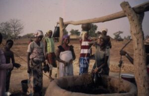
Figure 8 – Artisanal water well dug through the saprolite layer on top of crystalline bedrock in Burkina Faso, sub-Saharan Africa (photograph: Alain Rouleau).