5.2 Fracture Network Conceptual Models of Flood Basalts
The preferential flow paths in continental flood basalts may comprise a variety of components:
- laterally discontinuous, blocky (very fractured) and partially weathered vesicular basalt (Versey & Singh, 1982);
- sheet-jointed vesicular layers (Kulkarni et al., 1997; Pakhmode et al., 2003);
- highly fractured vesicular interflow zones between successive flow units (Johnson et al., 2002a; Douglas et al., 2007; Larson et al., 2000);
- fractures at the contacts between superior vesicular layers and compact basalt (Kulkarni et al., 1997);
- heavily fractured flow contacts (Johnson et al., 2002a);
- vesicular and scoriaceous interflow zones (McGrail et al., 2006);
- subhorizontal fractures interconnected by subvertical fractures of lower transmissivity (Tressoldi & Kitahara, 1991); and,
- long subhorizontal fractures at interflow contacts or at entablature and colonnade contacts (Fernandes et al., 2016a).
Most of the preferential groundwater flow paths in continental flood basalts are subhorizontal structures or layers, and this characteristic generally imparts a stratabound fracture network model. Despite the prominence of the cooling joints in both entablature and colonnade layers, the compact basalt is not the most conductive portion of the basalt flow. Fernandes and others (2016a) concluded that flow along vertical cooling joints is precluded or greatly reduced due to the presence of mineral infillings, the same as those found in vesicles. Larson and others (2000) point out that vertical flow is impeded by the entablature and colonnade flow interiors despite the presence of columnar cooling joints. The vesicular layers, even with a significant amount of vesicle voids, may work as regional hydraulic barriers to vertical flow because the vesicular voids are not connected, and vertical or horizontal fractures in those layers are scarce and discontinuous (Fernandes et al., 2016a).
Due to the generally minimal vertical connectivity of these horizontal aquifer levels, even when contained within one single basalt flood they are often modeled as multiple aquifer/aquitard systems (Douglas et al., 2007; Wanhfried, 2010). This approach is supported by studies based on the difference in hydrogeochemistry and isotope content of waters in the permeable zones (Versey & Singh, 1982; Larson et al., 2000; McGrail et al., 2006). In the eastern portion of the Columbia River Basalt Group, continuous water level declines in deeper aquifers have been observed in response to pumping from municipal water supply and private wells. This strongly indicates that the groundwater in the deep aquifers is being mined (Douglas et al., 2007). Larson and others (2000) report that water in the deep aquifers is old and has not been recharged under current climate conditions. Thus, it was concluded that the aquifer recharge rates to the deep basalt aquifer are substantially lower than previously estimated.
Structural data collected at several rock exposures, produced by excavations for the construction of dams in the southern states of Brazil, indicate that the basalt layers of the Serra Geral Formation can be divided in two prominent regions, each having distinct fracture network models. In the southernmost states of Rio Grande do Sul, Santa Catarina, and Paraná, subvertical, throughgoing, tectonic fracture zones cut across the basalt layers, including the vesicular zones, and probably cause the connection of the multiple aquifer levels. In contrast, the stratabound model can be regionally applied to the vast region of São Paulo State. In this area connection of subhorizontal flow paths by subvertical tectonic fracture zones occur only locally in the Serra Geral basalts as illustrated in Figure 45 (Fernandes et al., 2016a).
Flood basalt regions exhibit a great number of dikes and sills intruding sedimentary rocks. It is important to investigate their occurrence because they influence the groundwater flow. It has also been observed that boreholes in dolerite intrusion–host rock contact zones have significantly greater probability of yielding high quantity of groundwater (Sami, 1996). The dolerites that intrude the sedimentary rocks (sandstones and mudstones) of the Karoo Sequence in southern Africa act as both carriers of and barriers to groundwater flow (Gustafsson, 1994; Senger et al., 2015). A quantitative fracture analysis on outcrops in and around the dolerite intrusions (Senger et al., 2015) concluded that:
- fluid flow will most likely be focused along the intrusion–host rock contact zones (Figure 67); and,
- the central portion of the dolerite acts mostly as a barrier to flow because its fractures are generally mineralized and sealed.
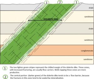
Figure 67 – Dolerite dikes intrude the sedimentary rocks of the Karoo Sequence in southern Africa and act as both carriers and barriers to groundwater flow. Senger and others (2015) concluded that fluid flow will most likely be focused along the intrusion–host rock contact zones, and that the permeability of the fractures decreases with depth. The intrusion process generated one joint set that is perpendicular to dike walls and another that is parallel (modified from Senger et al., 2015).