Exercise 16
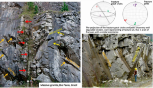
The two rock exposures in the Photographs below are in the same quarry and show three fracture sets; their respective great circles and poles are represented in the stereograms. In Photograph (a), the subvertical fracture zone (white arrow) belongs to fracture set 1 and consists of vertical, persistent (>80 m long) parallel fractures (N30–35W). They are occasionally infilled by narrow dikes (a few decimeters thick) of alkaline rocks (darker color depressions indicated by red arrows). Fracture zones that belong to set 1 can be tens of meters apart.
Photographs from Itapecerica da Serra, São Paulo, Brazil, by Bruna Fiume
a) What type of fractures do these characteristics, by themselves, indicate?
b) In which tectonic regime may they have been formed?
c) What was the possible orientation of the principal stresses at the time set 1 was generated?
Orange and yellow arrows in Photographs (a) and (b) identify fracture sets 2 and 3, respectively. Both strike EW and dip around 60o to 70o with set 2 dipping to the south and set 3 to the north.
d) What type of fractures and tectonic regime do these characteristics indicate?
e) What is the orientation of the principal stresses? The dikes that infill fracture set 1 are intensely weathered, which explains the depressions indicated by the red arrows in Photograph (a); conversely, the fracture surfaces of sets 2 and 3 are fresh.
f) Considering the fracture type of each set, the connectivity outlined by the orientations and persistence of the fractures, and the presence or absence of weathering, what would be expected with regard to the connected network and the groundwater flow anisotropy?