4.4 Systematic Collection of Data for Fracture Network Modeling
The geometric characteristics of each fracture set in a fracture network usually have a significant degree of variability that need to be quantitatively characterized in order to build conceptual and numerical models. Consequently, these geometric characteristics of fractures should be systematically collected over large outcrops, either along scanlines with variable orientations or using a window sampling procedure. Fracture data collection along vertical boreholes is desirable; however, this should be complemented by surveys along inclined holes with different orientations and, if possible, on rock exposures. This is necessary for the following reasons.
- Vertical boreholes do not provide sufficient sampling of high dip fractures.
- Natural fractures are not smooth parallel plates thus it is difficult to assign a representative flow descriptor to a fracture by inspection of small well images (Morin et al., 1997).
- Fractures, locally identified as permeable, are not always connected to the larger-scale flow systems and this cannot be observed in the small exposures provided by individual borehole walls (Paillet, 1991; Long et al., 1982).
- Larger-scale flow direction may be controlled by fracture zones rather than by the orientation of specific fractures intercepted by boreholes (Paillet et al., 1987). Consequently, the integration of information from boreholes and large rock exposures is needed to both formulate hypotheses and interpret hydraulic properties of the fractured rock over increasingly large physical dimensions (Shapiro et al., 2007; Fernandes et al., 2016b; and Fiume et al., 2020).
It is important to systematically collect data on fracture orientation, spacing, length, and interactions, as well as evidence of groundwater flow along fractures. Evidence of flow is generally manifested by weathering of the rock near the fracture or on its surface, as well as by the presence of vegetation and water leakage along the fracture (Figure 61, Figure 62, Figure 63). This systematic method of collection and interpretation of fracture data provides results that can be integrated to construct realistic conceptual and numerical models of fracture network connectivity and preferential flow pathways (Figure 64).
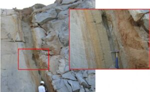
Figure 61 – Intense weathering along a subvertical fracture in massive granite is evidence of groundwater flow indicating that this fracture is significantly transmissive, Votorantim quarry, Metropolitan Region of São Paulo, Brazil (Fiume, 2013).
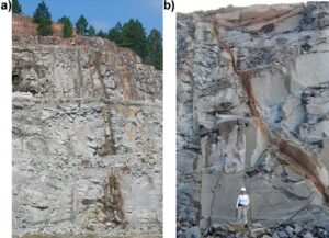
Figure 62 – Intense weathering along subvertical fractures in massive granite (Votorantim quarry, Metropolitan Region of São Paulo) that is otherwise fresh; the weathered fracture in (a) is more than 70 m long (Fiume, 2013).
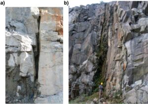
Figure 63 – Weathered fracture zones. a) A massive granite was deeply weathered at the fracture zone and the resulting loose material was eroded away forming a depression (Itapeti granite, Metropolitan Region of São Paulo) (photograph: Amélia Fernandes). b) Fresh massive granite with a deeply weathered subvertical fracture zone that sustains vegetation and was partially eroded away (Votorantim quarry, Metropolitan Region of São Paulo; photograph: Fiume, 2013).
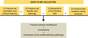
Figure 64 – Flowchart indicating the steps and the type of data (numbers 1–4) that have to be systematically collected in field surveys. The analysis of the data results in knowledge on the fracture network architecture and connectivity, as well as on the orientation of the preferential groundwater flow pathways. A detailed chart on interpretations that arise from data collected in step 1 is given in Figure 38.
Figure 38 presents a flowchart that synthesizes an interpretation procedure of fracture orientation and patterns. The combination the flow chart of Figure 38 with the flowchart of Figure 64 defines a strategic approach for the characterization of the fracture network configuration, as well as the indication of potential connectivity and preferential flow pathways. This scheme was deployed by the authors of this book (Fernandes et al., 2011; Pino et al., 2011; Fernandes et al., 2012, 2016a, 2016b) in the context of continental flood basalts and Precambrian crystalline aquifers. A similar strategy can be found in Peacock and Sanderson (2018); these authors state that vital inputs into modeling of fluid flow are provided by structural surveys and analyses that involve appropriate methods and terminology.