Exercise 17
A fracture survey along a total of 11 scanlines was conducted on subvertical exposures in a massive granite quarry. The image from Google Earth at the top left of the image below shows the location of two scanlines, line 1 and line 2, whose directions are N70W and N70E, respectively. The drawings of line 1 and 2 show the fractures observed on the respective quarry walls. The two Photographs show details of the walls.
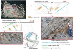
Photographs from Suzano, São Paulo, Brazil, by Amélia Fernandes
Fractures along these scanlines belong to sets 1, 2 and 3, as shown in the scanline sketches, Photographs, and stereogram below.
Fracture set 1 average strike is N20E, dipping around 35o to 40o in line 1, or 50–55o in line 2, toward NW. A distinctive characteristic of this set is that it frequently forms zones of parallel fractures as shown in Photograph (a).
Fracture set 2 average strike is the same as set 1, N20E, but it dips around 40o toward SE. Therefore, fracture sets 1 and 2 form an angle of around 80o to 90o with each other. Fracture set 2 frequently abuts against set 1 and the opposite also takes place.
Whereas sets 1 and 2 are planar, set 3 (average orientation is N70W/88SW) is wavy and includes narrow gouge zones, and its faces show subhorizontal striae lineation. Fracture sets 1 and 2 cut through set 3 and are not disturbed by it.
a) What are the types of displacements, the tectonic regimes and stress orientation that generated each of the sets? Explain your answer.
b) What can we deduce about the deformation history of the granite?
c) What are the implications of the fracture set characteristics for groundwater flow?