2 Stratigraphy and Structure
The aquifer rocks were formed during the Early Cretaceous on a broad carbonate shelf, referred to as the Comanche shelf, flanked by deeper basins to the south and west (Rose, 1972, 2019; Abbott, 1975; Sharp, 1990), which included the lands northwest of the Stuart City reef (Figure 16). The Maverick and North Texas basins are separated by the San Marcos Platform. The Devils River Reef fringed the Maverick Basin.

Figure 16 – Cretaceous depositional systems environments (Sharp, 1990; after Rose, 1972).
Aquifer hydrostratigraphy varies over a wide area (Maclay, 1995). The hydrostratigraphy of all segments of the Edwards Aquifer is shown in Figure 17 and reflects the various Cretaceous depositional environments. The aquifer is composed principally of the Edwards Group south of the Colorado River and composed of the Edwards and Georgetown formations north of the Colorado River. The aquifers may include more formations than just the Edwards Group or Edwards Limestone. The aquifer strata generally range in thickness from 60 m (197 feet) to 210 m (689 feet) in the San Antonio and Kinney segments; are about 140 m (460 feet) in the Barton Springs segment; and about 105 m (345 feet) in the Northern segment (TWDB, 2021). The aquifer, unless fault-bounded, thins to zero along the northwestern aquifer boundary.
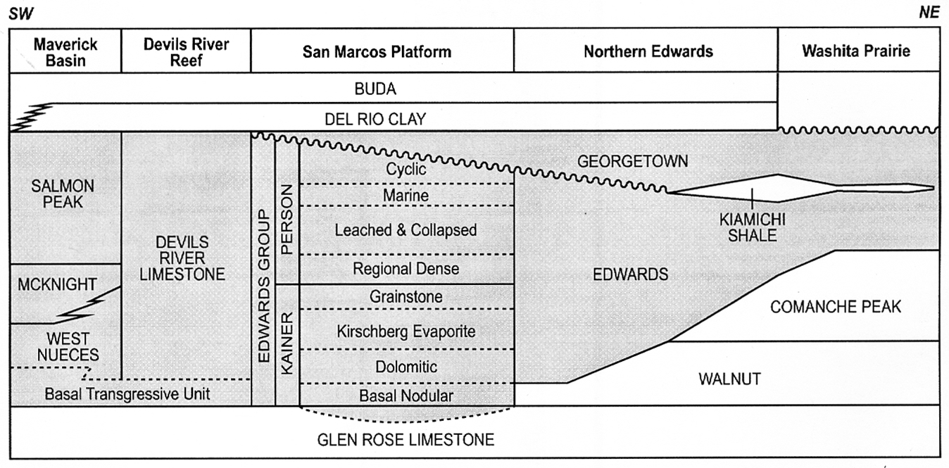
Figure 17 – Hydrostratigraphic units of the geologic formations (in gray) that form the Edwards Aquifer (modified from Sharp et al, 2019b). Formation names are in capital letters; dashed lines separate formation members (modified from Rose, 1972, 2017; Ryder, 1996).
Formation members south of the Colorado River are shown only for the Person and Kainer Formations of the Edwards Group in Figure 17. To complicate matters, the Edwards Aquifer is highly karstified, with rapid turbulent flow occurring in conduits, caves, and other preferential flow pathways formed by dissolution processes in the carbonate rocks. Karstification occurred during two episodes: (i) during the Cretaceous before deposition of the Georgetown Formation and (ii) more significantly after uplift, faulting, and exposure during the Cenozoic. In some areas, faulting has juxtaposed overlying and underlying units so that they act as part of the aquifer. These include the underlying Upper Glen Rose Formation (Hunt et al., 2019), which is part of the Trinity Group, and down-dropped sections of the overlying Buda Limestone and Austin Chalk formations that are hydraulically part of the aquifer in the Uvalde pool (Green et al., 2019b). The underlying and up-gradient portions of the Trinity Group contribute water flow to the aquifer in some areas via cross-formational flow (Clement and Sharp, 1987, 1988; Oetting, 1996; Johnson et al., 2019) or where they are juxtaposed to the Edwards Aquifer by faulting.
The Del Rio Clay is a gray, plastic clay, that was deposited in a shallow sea. It overlies the aquifer in the confined zone. It is an effective confining layer. The mineral composition is about 50 percent clay (10 percent smectite, 20 percent illite, 20 percent kaolinite), 10 percent quartz, 30 percent calcite and 10 percent amorphous material. Permeability data for the formation are lacking because the permeabilities are too low to be determined by most laboratory instruments. The Atterberg limits and swell potential in the Del Rio Clay are very high (Font, 1979; Font and Williamson, 1970), which is consistent with low-permeability clays and shales. The presence of flowing artesian wells, including some very large ones (such as the Catfish Farm well discussed in Section 4.1) over the confined zone of the highly permeable karst aquifer are also consistent with the Del Rio Clay having low permeability. Finally, numerical models do not require leakance through the Del Rio Clay because of its low permeability and the small area where upward cross-formational flow could occur.
Cross-formational flow from the underlying Trinity Group can be significant. This is supported by water balance estimates, numerical modeling, and water chemistry analyses (Clement and Sharp, 1987, 1988; Sharp and Clement, 1988; Oetting et al., 1996).
The geologic structure of the Edwards Aquifer is controlled by the Miocene-age Balcones Fault Zone (Hill and Vaughan, 1898; Weeks, 1945; Rose, 2019), which is an overall down-to-the-southeast system of normal faults associated with the transition between the Edwards Plateau and Gulf Coastal Plain province. The total structural offset can exceed 350 m over a distance of up to 50 km (Weeks, 1945; Collins and Hovorka, 1997). The Balcones Fault Zone cuts and juxtaposes rocks of the Cretaceous carbonate platform and overlying section—part of a regionally extensive carbonate-dominated sequence that extends in outcrop from central to west Texas (Lozo et al., 1959; Bebout and Loucks, 1977; Smith et al., 2000; Rose, 2017; Ferrill et al., 2019). Faulting also controls the outcrop patterns of the Edwards Aquifer, part of the Trinity Aquifer, and flow pathways within these aquifers (George, 1952; Holt, 1956; Arnow, 1963; Ewing and Caran, 1982; Maclay and Small, 1983; Maclay, 1989, 1995; Collins and Hovorka, 1997; Collins, 2000; Hovorka et al., 1998; Clark, 2000a; Ferrill et al., 2004, 2019). Regionally, the fault zone changes trend from nearly east-west between Del Rio and San Antonio to nearly north-south between Austin and Salado.
Locally, faults provide natural pathways for groundwater discharge mostly via springs that discharge within the confined (artesian) zone (Ewing, 1996). Intrusive and extrusive igneous activity in the Uvalde County and Travis County volcanic fields (Sharp, 1990, Figure 7 therein), that occurred approximately 82 to 80 and 74 to 72 million years ago (Miggins et al., 2004; Smith et al., 2008; Ewing, 2016), further complicate the regional structure (e.g., Clark et al, 2013).
At the largest scale, faults control the position and geometry of the aquifer (e.g., contributing, recharge, and confined zones) and, combined with stratigraphy, define regional flow paths. At the broad regional scale, the contributing zone is the southeastern Edwards Plateau at an elevation of > 350 m, the recharge zone is represented primarily by the Edwards Group outcrop belt at average elevations of ~300 m and is coincident with the Balcones Fault Zone. The confined zone lies south and southeast of this beneath the Del Rio Clay and younger sedimentary strata of Cretaceous to Miocene age. Faults and extension fractures—in many cases with permeability enhanced by dissolution—localize recharge and flow and are abundant at all scales within the Balcones Fault Zone and into the subsurface of the confined zone (Ferrill et al., 2019).
The juxtaposition of the Edwards Aquifer with other aquifers, especially the Trinity Aquifer, provides avenues for inter-aquifer communication (e.g., Ferrill et al., 2008; Johnson et al., 2010). On the other hand, juxtaposition against low-permeability layers (Maclay and Small, 1983), concentrations of clay in the fault zones, or mineralization along faults and fractures locally produce seals for compartmentalization and confinement of the Edwards Aquifer. This juxtaposition can lead to communication between the aquifer and permeable layers above and below the confining zones. The hydrologic behavior of faults varies as a function of position along the fault with respect to fault displacement, fault segmentation, and stratigraphic position, as well as the role of subsequent dissolution. At all scales, aquifer permeability parallel to faults is enhanced when compared to that of un-faulted rock (Hauwert et al., 2004).
Fault-block deformation including small faults and extension fractures also cause anisotropic permeability (i.e., permeability that varies with orientation). Faults and extension fractures localize recharge and flow. Groundwater flow and carbonate rock dissolution can enhance the permeability effects of fault and fracture systems. Fault displacements show a pattern of aquifer thinning that is likely to influence fault-block communication and flow paths. Flow-path constriction and tortuosity may be exacerbated by increased fault-segment connectivity associated with large displacements. Faulting over a range of scales can produce strong permeability anisotropy such that maximum permeability is sub-horizontal and parallel to fault-bedding intersections (Ferrill et al., 2019).
In rock layers like those that make up the Trinity and Edwards aquifers, groundwater flow and dissolution can enhance the permeability effects of fault systems. Fault zones commonly form relatively impermeable barriers to across-fault flow; form permeable pathways for along-fault flow; or form both barriers and pathways, often via relay ramps (Arnow, 1963; Caine et al., 1996; Knipe, 1997; Yielding et al., 1997; Ferrill and Morris, 2003a,b and 2007). Relay ramps transfer displacement from one fault to the next and can serve as unbroken groundwater flow pathways through a fault system where faults offset the aquifer or serve as flow barriers (Collins and Hovorka, 1997; Hovorka et al., 1998; Hunt et al., 2015).