2.8 Exchange at the Reach/Floodplain Scale
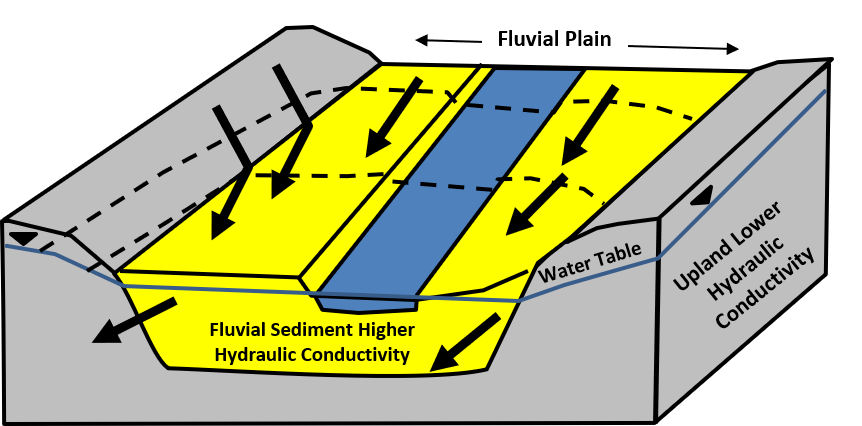
Groundwater and river exchanges viewed at the reach scale, 10’s of meters to kilometers, can contain a single exchange process or multiple exchange conditions. Exchange at the reach scale is influenced by the fluvial processes generating the reach/floodplain sediments. Woessner (2000) noted that in most settings dominated by unconsolidated sediments where groundwater is flowing towards the stream reach, the exchange is influenced by the presence of a contrast in hydraulic conductivity of fluvial the sediments that generally directs groundwater flow down floodplain (Figure 27).
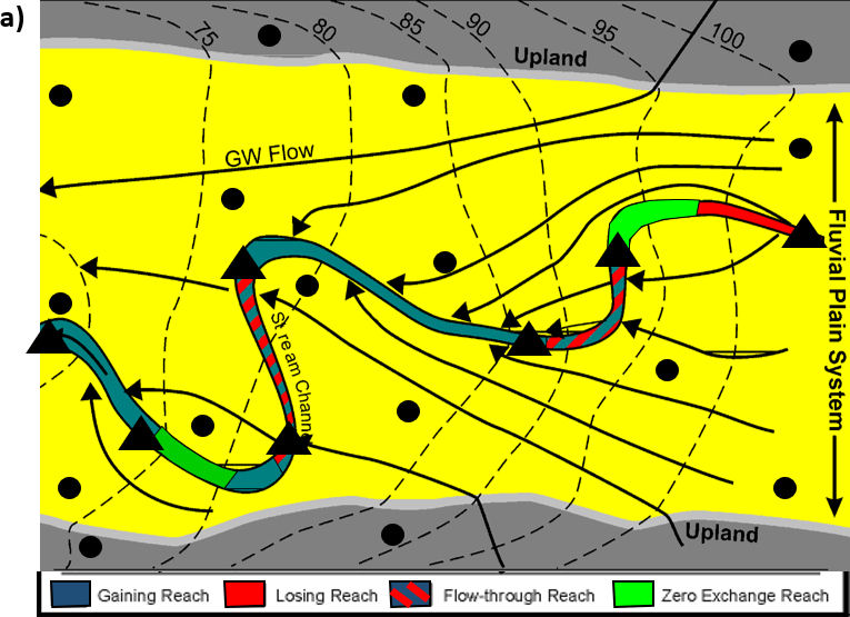
Quantifying exchange in a stream reach is most often based on how streamflow changes between two stream gauging locations used to define the reach (as was described in the valley segment exchange section above). In addition, the details of exchange along the reach is obtained by mapping the relationship of the stream stage to the water table in the vicinity of the reach (Figure 28).
Water levels in groundwater monitoring networks can be paired with stream stage measurements to derive two-dimensional and three-dimensional groundwater exchange patterns and locations. Reach-scale groundwater exchange is often simulated in groundwater models when rates, locations and timing of exchange is required to meet modeling goals. A variety of approaches and tools are available to simulate exchange (e.g., Anderson et al., 2015; Cardenas, 2015).
As presented earlier, a stream reach that is dominated by groundwater discharge (effluent or gaining stream) has increasing discharge between the up-stream and down-stream observation points. Under these conditions, the stream may exhibit a change in water chemistry that represents the addition of a different water type to the stream water. In losing reaches of streams the stream chemistry generally remains fairly constant because it is not mixing with groundwater. Instead, the groundwater chemistry associated with the stream will reflect its mixing with the stream water flowing into the groundwater system. Flow-through reaches may show chemical changes in both the surface water and the downgradient groundwater.
When the surface water and groundwater exchange, the surface water and groundwater may exhibit changes in ionic and isotopic compositions, and/or temperature (e.g., Healy et al., 2007; Boana et al., 2014). If there are significant contrasts in either the surface water or groundwater chemical compositions, chemical-mixing models may yield additional information on rates and locations of exchange at the reach scale, and/or reflect the geochemical signature of discharging groundwater. Section 5 describes appropriate methodologies for using such information to evaluate exchange locations and rates.
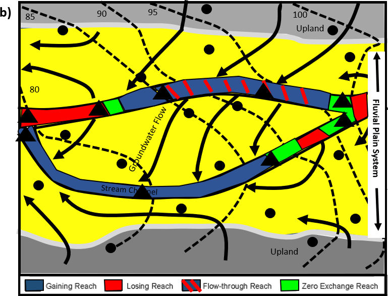
In some losing and flow-through stream reaches, stream water that recharges groundwater in the floodplain follows a flow path to an effluent stream section where the water that originated from the stream re-enters the stream. This process is observed over short flow paths associated with specific channel features as well as at the larger floodplain scale (Winter et al., 1998; Woessner, 2000; Diehl, 2004) (Figure 29). Water that flows from the stream through the groundwater system and returns to the stream is referred to as hyporheic water and the area where it occurs as a hyporheic zone (e.g., Woessner, 2017). At the reach scale this exchange process is three dimensional and influences the geochemical and ecological conditions in portions of the floodplain (e.g., Poole et al., 2008; Buss et al., 2009; Boana et al., 2014).
Again, it is important to note that, in some settings, even though the overall exchange process may be described as effluent or influent, multiple groundwater-surface water exchanges may be taking place between the defined reach boundaries (Figure 28). If the exchange investigations focus on shorter lengths of channel, different exchange processes may dominate.
Reach-scale exchanges are dynamic and can vary temporally and spatially. Variations in stream stage and groundwater flow systems in response to precipitation events, snowmelt, and droughts, as well as surface water and groundwater management can impact the type, location and flow rates of reach-scale exchange process.