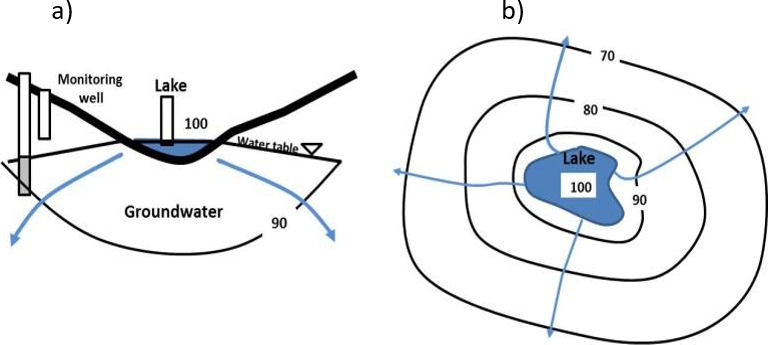
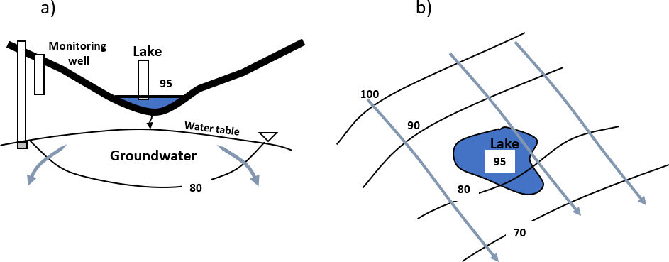
Influent or losing lakes leak lake water into the underlying and adjacent groundwater system (Figure 32b and c, Figure 34 and Figure 35). Hydraulic gradients between the lake surface and groundwater are downward. When earth materials are fully saturated, the lake is directly connected to the groundwater system as the lake loses water. Under these conditions the lake surface reflects the elevation of the water table. In contrast, when the zone of saturation is disconnected from the lake, water percolates to the underlying groundwater system (Figure 35). Influent conditions may be affected by lower permeability lake sediments restricting the rate of leakage to the groundwater system. The lake surface elevation under such conditions does not represent the water table. If leakage rates are large and hydraulic properties of the sediment low, mounding of groundwater below a perched lake can occur.
Figure 34 – Cross section and map view of influent (losing) lake exchange. Equipotential lines and relative head values are shown in black. Groundwater flow is in the direction indicated by blue arrows. Aquifer conditions are assumed to be isotropic and homogeneous. Monitoring wells are open at the bottom. a) Cross sectional representation showing a downward groundwater gradient and groundwater being recharged by the lake. Lake stage is shown as a water level on the vertical rectangle. b) A map view showing equipotential lines and groundwater flow diverging from the lake (Woessner, 2020).Figure 35 – Cross section and map view of influent (losing) lake exchange with the lake perched above the water table. Lake water percolating through the vadose zone is shown by a small black arrow beneath the lake. Equipotential lines and relative head values are shown in black. Groundwater flow is in the direction indicated by blue arrows. Aquifer conditions are assumed to be isotropic and homogeneous. Monitoring wells are open at the bottom. a) Cross sectional representation showing a downward groundwater gradient and the water table disconnected from the lake. The groundwater is being recharged by the lake. Lake stage is shown as a water level on the vertical rectangle. b) A map view showing equipotential lines and groundwater moving underneath the lake (Woessner, 2020).