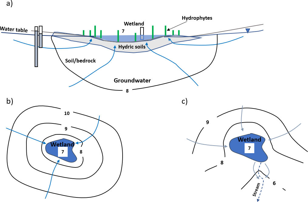
A wetland located in a groundwater flow system in which all groundwater flow is into the wetland is an effluent or gaining wetland (Figure 42). The wetland surface is an expression of the water table. In this setting, groundwater discharging to the wetland causes the water level to rise unless water is lost from the wetland as surface runoff and/or direct evaporation and transpiration. Water levels in the wetland change as the water budget varies (including changes in rates of evaporation and transpiration) and/or the discharge of water by streamflow (Figure 42c).
Figure 42 – Schematic cross section and map view showing a wetland dominated by groundwater discharge conditions, producing an effluent or gaining wetland. Equipotential lines and relative head values are in black. Groundwater flow lines are in blue. Isotropic and homogeneous conditions are assumed. Monitoring wells are open at the bottom. a) Cross section of a wetland showing groundwater flow to the wetland. Groundwater gradients are upward and the wetland stage represents the water table. b) Map view showing converging groundwater flow. c) Map view of an effluent wetland with a stream outlet (dashed line). The stream could be perennial or only flow occasionally. Some groundwater flows from the wetland when the stream is active (Woessner, 2020).
Springs and Wetlands
Wetlands often occur associated with springs. Box 2 briefly describes how groundwater discharge creates springs in a variety of hydrogeologic settings.
Wetlands are associated with spring and seepage-face discharge formed on slopes where groundwater discharge is sufficient to establish wetland vegetation and appropriate soil conditions as illustrated in Figure 43 (Mitsh and Gosselink, 2000). In locations where the topography intersects the water table, wetlands can be associated with a depression spring (Figure 43a). In some settings, groundwater discharge from bedding planes, fractures and joints in sedimentary and crystalline bedrock can provide sufficient flow to support wetlands at discharge points (Figure 43b and c).
Figure 43 – Schematic cross section showing wetland formation from spring discharge at slopes and depressions. Equipotential lines and relative head values are in black. Groundwater flow lines are in blue. Isotropic and homogeneous conditions are assumed in (a) and (b). Fracture and joint controlled flow are assumed in (c). a) Wetland formation when the water table intersects the slope forming a seepage face and intersects a depression in the slope. b) Wetland formed at the discharge point of a contact spring. Groundwater seeps out at the contact between higher permeability material and lower permeability earth materials. The spring may also form from a perched groundwater system. c) Schematic cross section of other geologic settings where spring flow may create wetlands if appropriate vegetation and soils are established. Not all spring discharge settings are conducive to wetland formation (Woessner, 2020).