2.6 Exchange at the Watershed/Basin Scale
Hydrogeologists generally characterize rivers, streams, creeks, brooks, canals and other linear flowing surface-water features as either receiving groundwater discharge or acting as a source of groundwater recharge (Figures 16 and 17). On a regional scale, this categorization may be appropriate, yet too simplified when assessing conditions at sites with smaller areas (e.g., Figure 15).
Toth (1963) addressed how regional/watershed scale groundwater systems covering large areas behave when recharge and geological conditions allow water tables to build up and reflect the topographic highs and lows of the landscape. In these settings if general groundwater discharge areas are assumed to represent exchange with a surface-water feature (river, lake or wetland), landscape-scale exchange locations and processes can be shown as illustrated in Figure 11 and 12. Toth examined how flow path length, water table topography, water table slope, anisotropy, and aquifer thickness impact groundwater exchange with discharge locations (viewed here as surface-water features). His work showed regional gaining streams can receive groundwater flow from a large regional flow system, an intermediate system, and/or a local flow system (Figure 11). In Toth’s (1963) landscape context, influent surface-water conditions occur if features located at topographic highs and groundwater divides recharged the groundwater. However, as stated previously, when combinations of recharge and geologic conditions do not create water table configurations that reflect surface topography, regional groundwater conditions may dominate exchange, and influent conditions can occur at topographic lows as well as features located in areas of groundwater divides (Figure 11 and Figure 12).
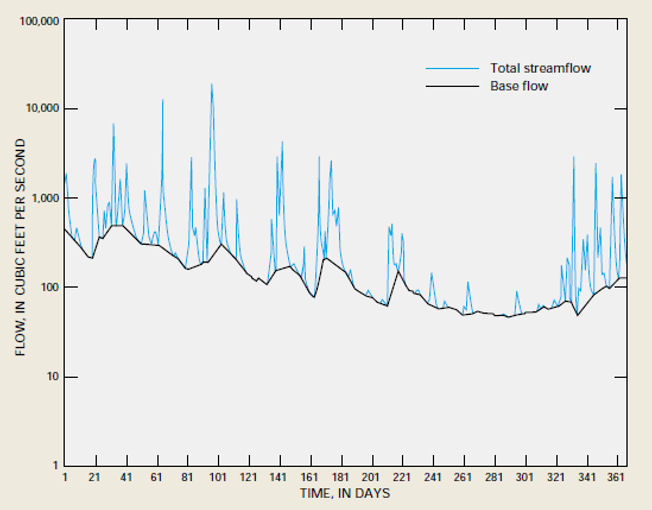
At the basin scale, when streams are dominated by effluent conditions, the flow records at stream gauging stations can be used to quantify a portion of the annual contributions of groundwater to the stream. Stream base flow represents a net addition of groundwater to the stream within the basin area above the gauging station (Figure 23). When streamflow is measured and other components of the basin water budget computed, groundwater contributions to streamflow are quantified (as discussed in Section 5.2).
Certainly, regional exchange locations and rates vary over time. Stream hydrographs document this variation. In addition, the locations and rates of exchange with headwater tributaries and arid-land streams vary depending on their interaction with groundwater and runoff.