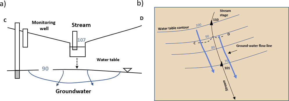
Influent or losing streams occur when the adjacent water table and the heads beneath the stream are lower than the stream stage. When the stream and water table are well connected (e.g., Figure 5) water flows directly from the stream channel to the adjacent groundwater (Figure 17a). In map view, when the groundwater and stream are fully connected, the groundwater flow diverges from the stream (Figure 17b). Equipotential lines point as a “V” downstream. Under these conditions, the stream stage represents the water table elevation.
Figure 17 – Cross section and map views of influent groundwater stream interactions (losing stream). Equipotential lines and relative head values are shown as blue water table contours. Groundwater flow is in the direction indicated by blue arrows. Aquifer conditions are assumed to be isotropic and homogeneous. Monitoring wells are open only at the bottom. a) Cross section showing a downward groundwater gradient and groundwater being recharged by the channel (Woessner, 2018). b) In map view, equipotential lines cross the stream and point in the downstream direction (V downstream). The location of the cross section in (a) (C-D) is approximated by the position of the dashed black line (after Healy et al., 2007).
In contrast, an influent stream can also be disconnected from the underlying water table in which case leakage to the groundwater is by percolation (Figures 18 and 19). When the stream is perched above the water table, the stream stage does not represent the local water table elevation. In some settings the leakage from the stream creates a groundwater mound beneath the stream and diverging flow paths occur (Figure 18a and b). When leakage rates are low and aquifer hydraulic conductivity is large the leakage can have little effect on the groundwater flow direction (Figure 19a and b).
Figure 18 – Cross section and map views of an influent stream (losing) perched above the groundwater flow system. The dashed arrow shows stream water percolating through the vadose zone to the water table. Black triangles are stream stage measurement locations and black numbers are stream stages. Equipotential lines and relative head values are shown as blue water table contours. Groundwater flow is in the direction indicated by blue arrows. Aquifer conditions are assumed to be isotropic and homogeneous. Monitoring wells are open only at the bottom. a) Cross section showing a groundwater mound formed beneath the channel. b) A map view showing equipotential lines that cross the stream, bowing downstream. Groundwater flow lines (blue arrows) are shown in this example as nearly parallel to the channel. The location of the cross section (C-D) is approximated by the position of the dashed black line (Woessner, 2020).Figure 19 – Losing (influent) stream perched above the groundwater flow system where stream recharge rates and hydrologic conditions cause minimal groundwater mounding beneath the stream. Groundwater flowlines (blue arrows) are shown as parallel to the channel in this example. Monitoring wells are open only at the bottom. a) The dashed arrow represents stream water percolating to the water table. b) Black triangles are stream stage locations and black numbers are stream stages. The water table is below the stream bottom and stream stages do not represent the water table elevation. The location of the cross section (C-D) is approximated by the position of the dashed black line (Woessner, 2020).