3.5 Lakes in Landscapes
In many settings, lakes occur within complex hydrogeologic settings, including those containing intermediate and regional flow systems and heterogeneity (e.g., Figure 1). Evaluating groundwater exchange with lakes is most commonly accomplished by generating a lake water budget and measuring and computing groundwater inflow and outflow to the lake as illustrated in Figure 38 (Winter, 1981). Box 1 provides details of Winter’s conceptualizations of lake-groundwater exchange. Water budgets can be used to examine exchange for a portion of the lake shore as well as the entire lake when components can be isolated. Section 5 of this book discusses methods for using water budgets to assess groundwater exchange with lakes.

Groundwater-lake exchange studies generally include instrumentation of lakeshores with monitoring well networks, and near-shore areas (littoral zones) and lake bottoms with instruments that physically measure seepage direction and magnitude known as seepage meters (Figure 39).

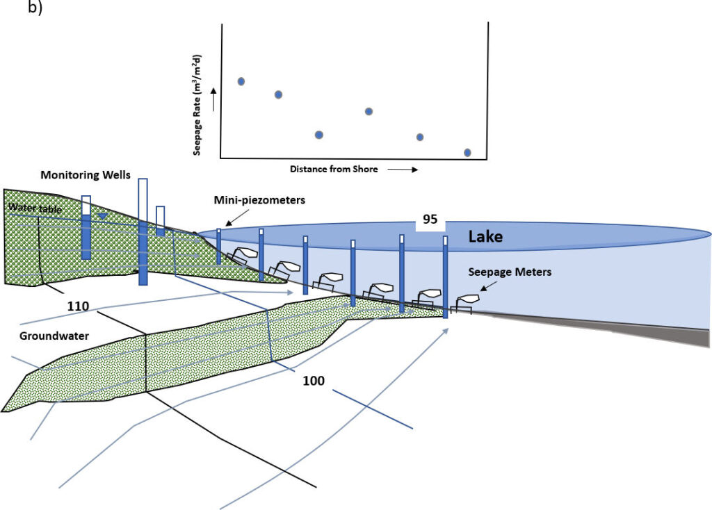
Small diameter monitoring wells (mini-piezometers) placed in the littoral zone and deeper parts of some lakes provide direct comparisons of groundwater heads and lake stages (Figure 39). These site investigations usually include chemical sampling of groundwater and lake water to assess whether variations in chemical characteristics of seepage water and lake water can be used as additional support of exchange. Rosenberry and LaBaugh (2008) provide an excellent set of chapters describing stream and lake characterization methodologies. Exchange in the near shore areas is typically evaluated using monitoring well networks, and in-lake paired installations of seepage meters and mini-piezometers (Figure 39). The application of seepage meters and mini-piezometers is described in the literature (e.g., McBride and Pfannkuch, 1975; Lee and Cherry, 1978; Rosenberry et al., 2008) and discussed in Section 5 of this book.
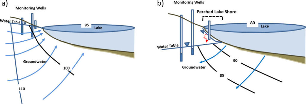
Lake groundwater exchange locations, rates and timing vary with changes in the local lake water budget. Lakes and reservoirs may be dominated by gaining conditions at one time of year and losing conditions at another (e.g., Figure 10). Anderson and Munter (1981) found transient groundwater conditions associated with a flow-through lake in Wisconsin, USA, resulted in the occurrence of seasonal stagnation points at some locations within the local groundwater flow system. Rosenberry (2000) noted that as groundwater levels adjacent to a lake fall more rapidly than the lake level the near-shore portion of the lake can become perched (Figure 40).
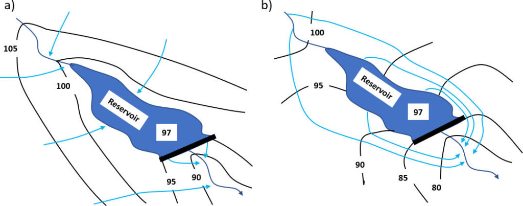
Construction of reservoirs by damming streams also results in exchanges between groundwater and the reservoir. When original stream conditions are generally effluent, groundwater typically feeds the upper end of the reservoir and receives leakage of reservoir water in the downstream area associated with the dam (Figure 41a). When reservoirs are placed in mostly influent stream conditions, reservoir water may remain higher than the surrounding groundwater, or be perched above the water table and create conditions where reservoir water leaks into the adjacent groundwater (Figure 41b). The stream below the dam may become effluent for a portion of the reach if sufficient reservoir leakage occurs.
Dams create bodies of surface water that exchange water in a similar manner as lakes and often will include effluent, influent and flow-through conditions at various locations and times. Reservoir stages are often managed to control flooding, provide for a municipal water supply, generate power, and/or divert irrigation water to croplands. As such, stages can be dynamic, changing with seasonal conditions and water use demands. Reservoirs, as with most lakes, slow stream inflows and promote deposition of finer sediment, materials that often blanket the bottom resulting in a reduction of groundwater-surface water exchange over time. In some tributary settings small dams are being installed to promote temporary storage of surface-water runoff. In these settings the associated water table tends to increase in elevation as water builds up in the small reservoirs. These reservoirs and associated wetlands promote delayed water transfer by new hyporheic flow of stream water and stored groundwater to the downstream channel. These modifications may slow streamflow declines during dry periods of the year.