1.1 Principles and Concepts
This section describes the basic physical principles driving groundwater-surface water exchange. Groundwater is defined as the water that occurs in the zone of saturation. Most groundwater exchange is between near surface unconfined (i.e., water table) systems and surface-water features. Surface water is water that occurs on the land surface as rivers, streams, lakes, and wetlands. This section addresses the spatial and temporal variations in the transfer of water between groundwater systems and surface-water features. It also presents conceptual models of groundwater exchange with streams, lakes, and wetlands. The ocean and associated components (e.g. estuaries) are also considered surface water. Exchange with coastlines is discussed briefly in this first section. Exchange also influences the water quality of surface water and groundwater and how each system interfaces with the adjacent aquatic and terrestrial ecosystems. To expand the physically based conceptual models presented in this book, the reader is directed to work by Conant and others (2019) that presents multiple conceptual flow charts used to build a framework of physical, biological, ecological and geochemical processes that both influence and are a result of the exchange processes.
Physically, groundwater moves from recharge areas to discharges areas, often originating from or discharging to surface-water features. Recharge and discharge areas vary greatly and are dictated by hydrologic conditions and the landscape framework (including hydrogeologic properties). In addition, surface-water systems exchange water with groundwater systems. Such relationships should be reflected when conceptualizing multi-scale groundwater and surface-water budgets (Figure 1).
The exchange process is driven by: 1) the relative elevation of surface-water features and associated groundwater head distribution in the adjacent and underlying groundwater system; 2) the hydraulic properties and composition of the sides, banks and bottoms of surface-water features; and, 3) the underlying geologic framework composition and structure. Challenges in documenting exchange sites and rates include the significant differences in residence times and flow paths of connected groundwater and surface-water systems.
Generic cross sections and map views are typically used to illustrate the steady-state and three-dimensional exchange processes. Sequences of cross sections are used to provide illustrations of changes in exchange under transient conditions.

Conceptual models of rivers, lakes, and wetlands have been developed by a number of authors (e.g. Freeze and Cherry, 1979; Winter et al., 1998; Woessner, 1998; Fetter, 2001; Woessner, 2000; Anderson et al., 2015; Weight, 2019). Depending on their discipline, researchers use different terms to describe the same conditions (Table 1). Models for rivers are presented in Figure 2.
Table 1 – Groundwater-Surface Water Exchange Terminology (Woessner, 2020).
| Discipline | Groundwater flow to Surface Water | Surface Water Flow to Groundwater | Groundwater Flow to and from Surface Water | No Groundwater Exchange |
| Groundwater Scientists | Effluent Conditions | Influent Conditions | Flow-Through Conditions | Zero-exchange or Parallel Flow |
| Surface water Scientists | Gaining Conditions | Losing Conditions | Flow-Through Conditions | NA |
| Aquatic Ecologists | Upwelling Conditions | Downwelling Conditions | Flow-Through Conditions | NA |
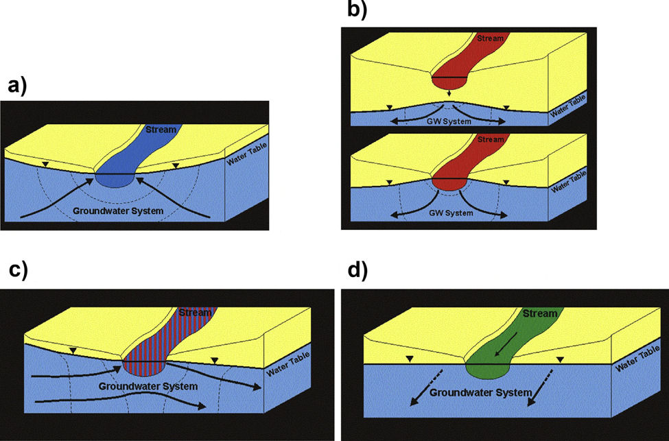
Hydrogeologists refer to settings where groundwater is discharging to surface water as effluent conditions; when groundwater is being recharged by surface water as influent conditions, and in situations where both conditions are present in a single feature as flow-through (e.g. lake flow-through conditions). This terminology is focused on the groundwater system (e.g., Todd and Mays, 2004). An effluent stream, lake, or wetland setting is receiving flow from the groundwater (groundwater is discharging, exiting the groundwater system). Scientists focused on characterizing surface-water features often describe the exchange process as it affects the surface-water feature. For example, they define an effluent reach of a stream as a gaining stream, the stream is receiving groundwater flow and the stream discharge downstream is increasing (e.g. Winter et al., 1998). A losing stream reach is one where groundwater is being recharged as the stream water leaks out of its bed and banks (influent conditions) and downstream discharge is decreasing. Flow-through conditions are generally used by both groups to describe conditions when water is entering and exiting a surface-water body at multiple locations. For streams embedded in a groundwater system in which no exchange is occurring, the term zero-exchange condition or parallel flow can be used (e.g., Figure 2). A third group of scientists have developed a descriptive set of terms also based on stream-groundwater interactions. Stream ecologists often refer to effluent streams as a site of upwelling (groundwater discharge) and influent streams as downwelling (surface-water recharge) (e.g., Hauer and Lambert, 2017). They rarely describe flow-through or zero-exchange settings. Thus, a portion of a surface-water body or coastline receiving groundwater discharge can be described as under the influence of effluent, gaining or upwelling conditions, and when surface water infiltrates its banks, shoreline and bed, conditions are described as influent, losing or downwelling.
The physical exchange process can be generalized and conceptualized using four schematic representations: 1) effluent or gaining; 2) influent or losing (two settings); 3) flow-through; and, 4) parallel flow or zero exchange. Generic conceptual models are presented in a cross section with a rectangular surface-water feature, which can be visualized as representing a stream, lake or wetland at various scales (Figure 3). Coastline exchange is discussed briefly at the end of this section. Map views of groundwater conditions associated with rivers, lakes, and wetlands are presented later in this book when each surface-water feature is specifically addressed. The general conceptual models illustrate that the groundwater water framework (geology) and interface conditions (surface-water body beds and banks) could have heterogenous and anisotropic hydraulic conductivity values (e.g., Figure 3). Of course, the world is three dimensional as is the geologic framework controlling groundwater flow rates and directions, so heterogeneity is present, and flow occurs in the third dimension that is not shown in these two-dimensional illustrations. In transient settings, each hydrogeologic material also requires an appropriate value of storativity to account for changes in groundwater storage.
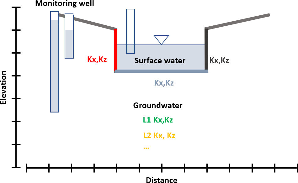
Further simplifying the generalized model shown in Figure 3, conceptual cross sections are presented in subsequent sections for each of the exchange processes. In the conceptual cross sections, horizontal and vertical scales are generalized (no units are shown) in order to represent multiple scales (mm, cm, m, km, and so on). Groundwater heads are represented as shaded water levels in monitoring wells (vertical rectangles) and surface-water stage by the shaded water and water level shown in the vertical rectangle. The general head distribution is indicated by water levels in monitoring wells that are open at the bottom and equipotential lines are labeled with unitless relative values. For illustration purposes, flow lines are constructed assuming no vertical exaggeration in the cross sections, each cross section is constructed parallel to groundwater flow, and a single hydraulic conductivity value is assigned to the earth materials such that conditions are isotropic and homogeneous. Certainly, there are many possible combinations of conditions that influence the final groundwater flow lines and exchange flux rates; these are not accounted for in the schematic representations. Exchange is inherently transient in nature; however, to simplify the discussion, steady-state groundwater conditions are assumed.