1.8 The Scale of Exchange
Cross sections can be used to represent the exchange process at various dimensions depending on the site context. For example, at the landscape scale, hydrogeologists generally visualize surface-water features as either receiving groundwater discharge or acting as sources of groundwater recharge (e.g., Figure 11). Toth (1963) developed a regional conceptual model that shows nested groundwater flow systems, and multiple groundwater recharge and discharge locations (exchange sites). In the context of groundwater-surface water exchange, surface-water features corresponding with discharge areas are effluent and features located in recharge areas are influent. When a topographically varying landscape receives sufficient groundwater recharge so that the water table is higher and mirrors topographic highs, then local, intermediate and/or regional flow systems develop (Figure 11a). In settings where recharge rates and geologic conditions do not create a water table that mirrors the topography, some surface-water features may occur where water collects in topographic lows. These features can act as a recharge sources under these conditions (Figure 11b). Regional groundwater exchange is also influenced by the distribution of the hydrogeologic properties of the underlying geologic framework. Hinton (2014) schematically shows variations in flow system exchange locations as influenced by the hydraulic conductivity distribution (Figure 12).


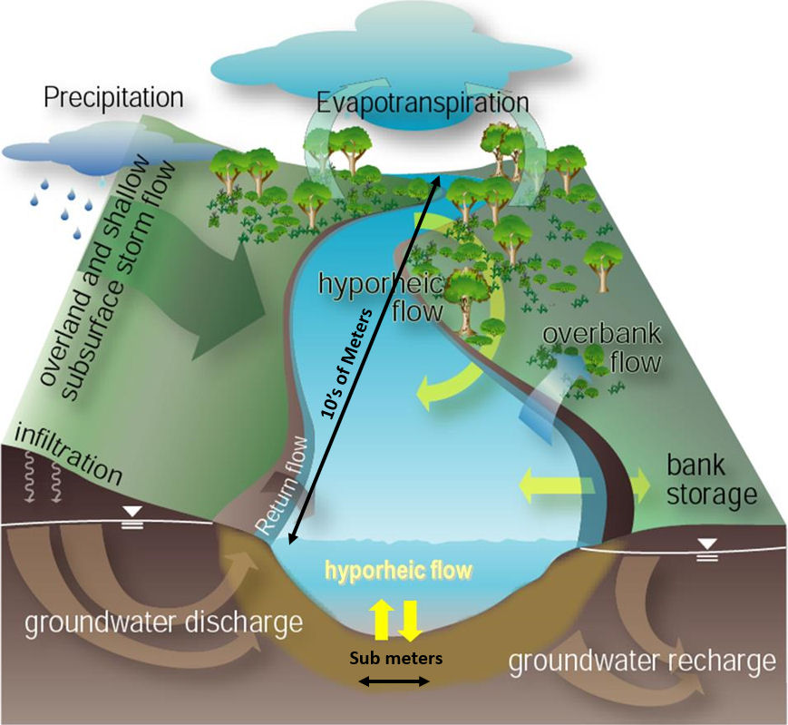
Exchange occurring at the scale of tens of meters to meters, and the sub-meter scale add complexity as slight variations in bed and bank configuration and elevation, hydraulic properties and hydraulic gradients drive local exchanges (Figure 13). Though often requiring extensive instrumentation, exchange at these scales is not only of interest to hydrogeologists, but also to those linking ecological systems to surface-water features and those focusing on exchange of contaminants (e.g., Hauer and Lambert, 2017; Conant, 2004; Conant et al., 2019).
Transient Changes in the Exchange Process
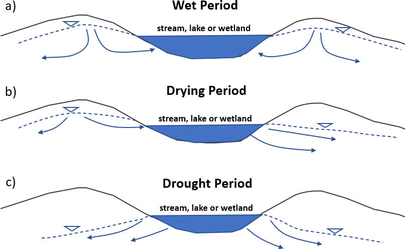
In some settings, exchange conditions are influenced by temporal long- or short-term hydrologic conditions such as seasonal variations in water availability, stage responses to individual storm and flood events, and changes in surface-water temperatures. Such conditions result in temporal changes in rates and locations of groundwater exchanges with streams, lakes and wetlands (e.g., LaBaugh and Rosenberry, 2008) (Figure 14). For example, when the water table rises in response to a wet period a surface-water feature may become a gaining feature that was previously influent. However, when groundwater recharge becomes limited during drying periods and/or drought, a gaining feature could become flow-through and/or losing later in the year (Figure 14). When rapid changes in surface-water stage occur in response to a short-term precipitation event or resulting flooding, exchange conditions may change from gaining to losing and then, as surface-water stages decline, gaining conditions are re-established (e.g., bank storage, Freeze and Cherry, 1979, p. 225-226). Influent seepage rates can also be impacted by surface-water temperature changes (e.g., Constantz et al., 1994). This occurs because vertical bed hydraulic conductivities increase and decrease slightly as surface-water temperatures vary (changes in the specific weight and viscosity of water) (e.g., Freeze and Cherry, 1979; Fetter, 2001). Zamora (2007) suggests temperature impacts on seepage rates should be evaluated to determine if seasonal surface-water temperatures impact local seepage rates. Activation of production wells impacting the shallow groundwater system near surface-water features may locally reverse the surface-water exchange (e.g., Barlow and Leake, 2012). Studies of exchange using only a snapshot analysis (single moment or period) are often insufficient to characterize seasonal and longer-term trends in the movement of water between surface-water features and groundwater. Thus, in most settings, researchers assessing exchange processes should design studies that account for changing conditions.
The conceptual models presented in Figures 4 through 14 represent the baseline conditions underlying similarities and differences of exchange process in rivers, lakes, and wetlands. The next three sections use these conceptual models to describe exchanges with streams, lakes and wetlands.