3.4 Borehole Extensometer
Continuous measurements of soil deformation in a (normally small) number of locations in a subsiding area have been carried out using borehole extensometers. They are used to measure the change in the distance between the land surface and a subsurface benchmark situated at the bottom of a deep borehole. If the subsurface benchmark is established below the base of the compacting aquifer system or in the bedrock, the extensometer can be used as the stable reference for local geodetic surveys. The first borehole extensometer was installed in 1955 by the United States Geological Survey in the San Joaquin Valley, California, USA (Poland, 1984). Since then, extensometer technology has seen progressive improvement, playing an important role in relating land subsidence to the compaction of confined aquifer systems.
Several types of early borehole extensometers are reviewed by Poland (1984). Recently, anchored cable counterweighted extensometers and slip‑joint casing extensometers have been widely used. The measuring devices are schematically shown in Figures 24a and 24b. A typical cable counterweighted extensometer tool consists of a balance beam carrying a cable or a pipe, which is fastened at one end to an anchor weight located at the bottom of the compacting system, and at the other end to a counterweight keeping the cable at a constant tension (Figure 24a). To build up a sliding‑joint casing extensometer, a hole is drilled to a depth where rock is stable. The hole is then lined with a steel casing with slip‑joints to prevent crumpling as subsidence occurs. An inner pipe rests on a concrete plug at the bottom of the borehole and extends to the top. This inner pipe then transfers the stable elevation to the surface. Measurement of the distance from the inner pipe to the surrounding land surface provides the amount of compaction that has occurred over a given time interval (Figure 24b). A computer‑controlled system records the compaction data against time. The instrumental precision heavily depends on the actual extensometer implementation, but a nominal deformation resolution of 0.01‑0.1 mm can be achieved over a 200‑1000 m depth (Riley, 1986).
In the case of multi‑aquifer systems, extensometer stations are composed of close multiple‑borehole extensometers installed at different depths, so as to derive the deformation of each single formation by subtracting the records acquired at various depths. A recent alternative to multiple‑ extensometer stations are multiple‑position borehole extensometers that incorporate a number of independent markers anchored to the formation borehole at different depths (Figure 24c). Magnetic markers have been used in Taiwan (Hwang et al., 2008; Hung et al., 2012) to compute vertical compaction in boreholes using repeat borehole logging with magnetic sensors on calibrated lines or tapes in order to measure temporal changes in marker positions. This method is capable of monitoring from ten to several tens of marker positions in a single borehole at measurement resolutions of about 1‑2 mm over a depth of several hundred meters.
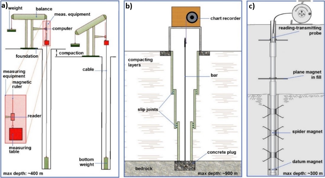
Figure 24 ‑ Schematic representation of a) a single‑layer cable extensometer; b) a slip‑joint casing extensometer; and, c) a multilayer magnetic borehole extensometer used to record the deformation of aquifer‑aquitard systems.
A relatively dense network of extensometer stations has been established in metropolitan areas experiencing significant land subsidence. Two major examples are Houston, Texas, USA and Shanghai, China. The Houston‑Galveston area is an extreme example of subsidence hazards, a problem that affects many other USA metropolitan areas, for example: Los Angeles, California; Sacramento, California; and New Orleans, Louisiana. Portions of Houston experienced severe settlement, up to 3 m, from 1915 to 2001. The United States Geological Survey has been operating 13 borehole extensometers at 11 sites since 1973 for the purpose of observing compaction of aquifers in the area. The borehole extensometers, which were designed according to the sliding‑joint casing type, span a depth down to 936 m (Yu et al., 2014). Shanghai is the first city in China where land subsidence was investigated and monitored, being one of the country’s most densely populated and developed areas. The maximum cumulative land subsidence was 2.6 m in 2002 and the total area of land subsidence was about 5000 km2 in 2006. A number of the 27 extensometer groups have been used since the 1960s to monitor compaction of individual aquifers and aquitards to a depth of approximately 350 m (Wu et al., 2010).
Horizontal extensometers were used to measure differential horizontal ground motion at earth fissures caused by changes in groundwater levels in South‑Central Arizona, USA (Carpenter, 1993). Buried horizontal extensometers made of quartz tubes or invar wires were used to precisely and continuously measure fissure opening in a natural environment over a scale of 330 m. Following enlargement of the ground rupture occurrence in several countries worldwide, other specific mechanical and optical instrumentation has recently been developed and used in urban areas such as Iztapalapa, Mexico City, Mexico (Carreon‑Freyre et al., 2010), and Beijing, China (Zhu et al., 2015). These monitoring stations allow one to accurately measure the relative displacements characterizing the rupture in a 1‑D (only opening) or 3‑D (opening and sliding) reference system as shown in Figure 25.
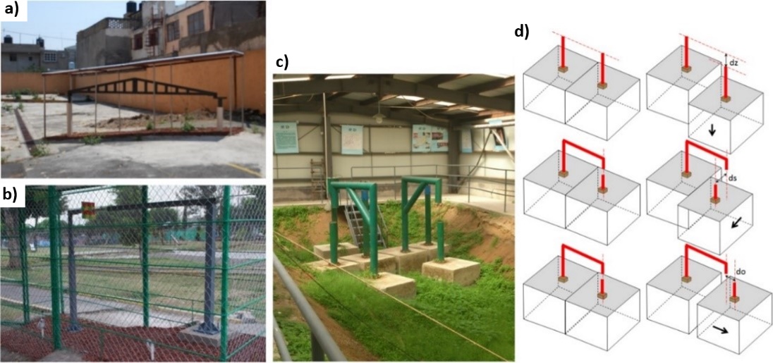
Figure 25 ‑ Some examples of ad hoc instrumentation developed to monitor opening and sliding of earth fissures or faults activated by the overdraft of aquifer resources. a) 1‑D apparatus and b) 3‑D apparatus established in Iztapalapa, Mexico City, Mexico (courtesy of Dora Carreon‑Freyre, Centro de Geociencias, National Autonomous University of Mexico). c) 3‑D instrumentation installed in the northern Beijing plain (courtesy of Lin Zhu, Normal Capital University, Beijing, China). d) A sketch showing how 3‑D movements can be measured through the apparatus established in the Beijing plain.