5.1 Ground Ruptures
Ground ruptures associated with land subsidence caused by groundwater withdrawal have been reported from many alluvial basins in semiarid and arid regions since the late 1970s. Examples occur in the southwestern USA (Holzer et al., 1979; Jachens and Holzer, 1979; and, Holzer and Galloway, 2005), central Mexico (Pacheco et al., 2006; and Carreon‑Freyre et al., 2016), Iran (Ziaie et al., 2009; and Mahmoudpour et al., 2013), Saudi Arabia (Bankher and Al‑Harthia, 1999), Pakistan (Khan et al., 2013), and China (Shi et al., 2007; Wang et al., 2009; and He et al., 2017).
Fissure development has been observed both within areas where natural resources are exploited and along the area boundaries. Density, shape, length, aperture, depth, and dislocation of the fissures vary greatly from site to site, and are mainly related to subsoil lithostratigraphic variations. In several places only a few isolated fissures have formed; in others, many. Fissures vertically dislocated more than 2 m have been observed, up to 15 km long, 1‑2 m wide, and 15‑20 m deep. Considerable economic, social, and environmental damage is reported. Damage includes the rupture of borehole casings, pipes, and canals used for withdrawing groundwater and conveying water, oil and gas. Impacts occur in both rural zones, where the water is mainly used for crop production (for example, in the Sarir agricultural area, Libyan desert, and in southcentral Arizona, USA), as well as in urban areas (for example, in Mexico City, Queretaro, Mexico, and Celaya located within the Trans‑Mexican Volcanic Belt in Mexico; in Beijing, Xian, and Wuxi China). Other consequences include the reduction of potable water supplies; cost increases for groundwater extraction; damage to surface structures (for example, houses, historical palaces, churches, and other buildings); cracking of infrastructure such as streets, water pipes, railways, and runways; injuries to livestock and other animals as well as to people; creation of preferential flow paths for contaminants from the surface into shallow aquifers, and triggering of severe soil erosion and creation of badlands topography near the rupture (Figure 30).
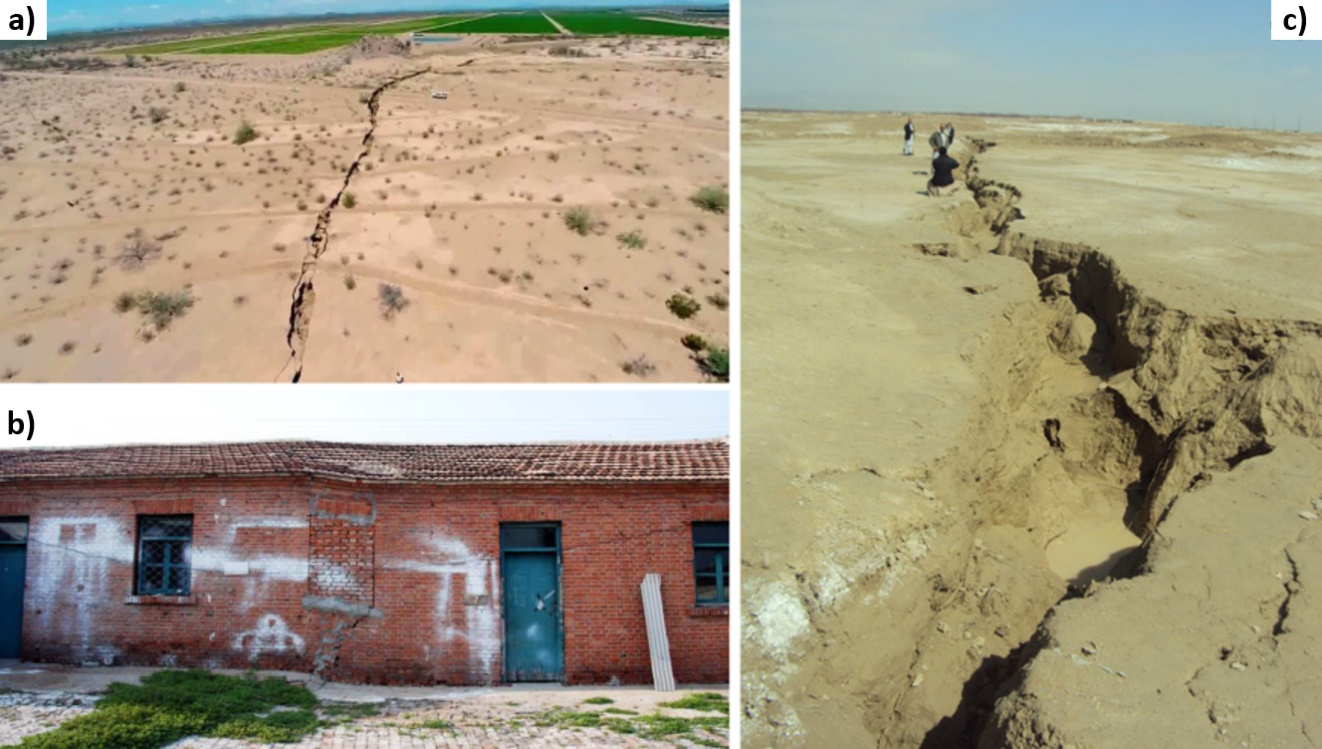
Figure 30 ‑ A few examples of earth fissures due to groundwater pumping in a) Arizona, USA (courtesy of Joe Cook, Arizona Geological Survey, Tucson, AZ); b) damaging a house in Shunyi, Beijing, China (courtesy of Lin Zhu, Normal Capital University, Beijing, China); and, c) in Quetta, Pakistan (courtesy of Najeebullah Kakar, University of Balochistan, Quetta, Pakistan).
Several mechanisms have been proposed to explain the origin of ground rupture associated with the development of natural resources. Representations of a few proposed mechanisms are shown in Figure 31 (Holzer et al., 1979; Sheng and Helm, 1998; and Sheng et al., 2003). According to the direction of pumping‑induced stresses below the surface, we may identify two main types of ground rupture: tensile fissures and shear fissures (Holzer and Pampeyan, 1981). The main difference between these two fissure types is the vertical offset observed in the field. Typically, tensile‑induced earth fissures create slight or no offsets, while shear‑induced earth failures have measurable scarps (Holzer and Pampeyan, 1981). However, this distinction may be difficult to recognize in urban areas, where some shear‑induced ruptures initially appear without any vertical offset, as structures/infrastructures on the land surface mask the actual rupture displacements.
Starting from the early 2000s, research was mainly focused on modeling, and hence predicting, ground failure. A Mohr‑Coulomb failure criterion was used by Budhu (2008) to analyze fissure initiation in heterogeneous sedimentary deposits. He found that the most potent mechanism for earth fissures formation combines bending and shearing. Geological discontinuities are the preferred location for ground failure to occur, with ruptures that initially form at the surface and then propagate downward, or vice versa, depending on the prevailing mechanisms. Using a continuum approach and the ABAQUS geomechanical simulator software (https://www.3ds.com/products-services/simulia/products/abaqus/), Hernandez‑Marin and Burbey (2010, 2012) studied the spatial distribution of deformation, and normal and shear stresses that potentially lead to the formation of ground ruptures. Their results indicate that the presence of a preexisting fault zone largely controls the deformation and stress regime of the porous medium during pumping, with areas of stress accumulation that may eventually lead to fissure formation. The simulations were carried out on 2‑D vertical sections representing the Las Vegas Valley.
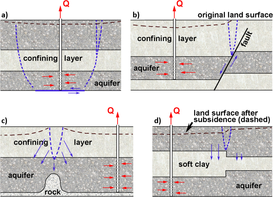
Figure 31. Sketches of some mechanisms that induce ground ruptures (dashed blue lines): a) horizontal displacement due to shearing on the plane of weakness or to tensile failure; b) reactivation of an existing fault caused by horizontal displacements; c) tensile fracture above a bedrock ridge; d) differential compaction due to heterogeneous thickness of [aquifer (rigid)]/[aquitard (compressible)] layers (modified after Sheng and Helm, 1998). The red and blue arrows represent the flow and displacement fields, respectively.
Recently, an original numerical approach based on “Interface Elements” (IE), developed to simulate the possible activation of regional faults due to hydrocarbon production (Ferronato et al., 2008; and, Jha and Juanes, 2014) has been used to simulate the earth fissure generation and propagation caused by groundwater pumping in Wuxi, China. Groundwater pumping between 1985 and 2004 has caused land subsidence larger than 2 m (Ye et al., 2018). The model outcomes show the presence of a shallow (~80 m deep) bedrock ridge crossing the Yangtze River delta is the key factor triggering earth fissure development in this area (Figure 32). Bending of the alluvial deposits around the ridge tip and shear stress due to the uneven piezometric change and asymmetrical shape of the bedrock have caused the earth fissure to form at the land surface and propagate downward to a maximum depth of approximately 20 to 30 m. Maximum sliding and openings are computed to be in the range of 10 to 40 cm, respectively.
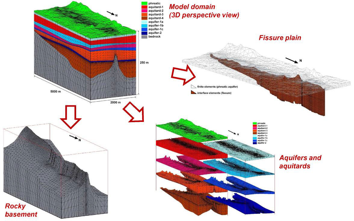
Figure 32 ‑ 3‑D FE‑IE mesh developed by Ye et al. (2018) to model land subsidence and earth fissure propagation in Wuxi, China. The various geologic components (bedrock, aquifers and aquitards, fissure) are highlighted with different colors and enlarged in the sub‑panels (modified from Ye et al, 2018).
The geomechanical model of earth fissuring and fissure activation is based on the structural equations of poroelasticity (as discussed in Box 3) solved in a three‑dimensional setting with the aid of the FE‑IE approach. While standard FEs are used to represent a continuum, IEs prove especially effective in examining the relative displacements of adjacent elements, such as the opening and slippage of preexisting faults or the generation of new fractures (using an elastoplastic constitutive law based on the Mohr‑Coulomb failure criterion). A zero‑thickness IE compatible with linear FE consists of a pair of linear elements (1‑D in a 2‑D problem, 2‑D in a 3‑D problem) with the opposite nodes coinciding. The interface displacements in the local reference frame associated with each element are the aperture δn and the slippage δs1 and δs2 between the “top” and the “bottom” face of the element. The displacement components are related to the interface stresses σn, τs1, and τs2, with σn taken as the normal stress (negative in compression, positive in expansion), and τs1 and τs2 as the shear stress components in the interface plane. Irreversible plastic displacements of the interface may take place wherever the limiting tensile or the shear strength are exceeded. Assuming conservatively that no tensile strength is allowed, the opening of fissure/fault surfaces occurs when the stress normal to the interface plane, that is, σn, becomes positive. Irreversible slip occurs when the Mohr‑Coulomb failure criterion is violated. Sealing fissures, that is, ones with a no‑flux surface, are simulated allowing the pressure gradient acting on the contact surface to be different.
Ground ruptures are the focus of the recently funded UNESCO‑IGCP641 project M3EF3 (Mechanisms, Monitoring and Modeling Earth Fissure generation and Fault activation due to subsurface Fluid exploitation). A large amount of material about ground ruptures can be found in the project website (http://www.igcp641.org/).