1.2 Historical Framework
The first observation relating land subsidence to subsurface fluid removal was made in 1926 by the American geologists Pratt and Johnson (1926), who discussed land settlement on the Gaillard peninsula, in the center of Goose Creek Oil Field on Galveston Bay (Texas). They concluded that ”the Goose Creek subsidence was directly caused by the extraction of oil, water, gas, and sand from beneath the surface beginning in the year 1917”. They also made a conjecture concerning the mechanism governing the underlying process, postulating that “the pore spaces are occupied by water draining more slowly from the adjacent clays; and it is a well‑known fact that the draining of clays causes them to become more compact, and this in turn would permit subsidence of overlying surface”. However, a few years earlier, Fuller (1908) had already theorized that fluid withdrawal and a decrease in fluid pore pressure caused the sinking of the land surface because of the removal of hydrostatic support.
It is interesting to note how the general public’s perception of anthropogenic land subsidence has drastically changed over time. Today the occurrence of settlement affecting large areas is a matter of great concern from a variety of viewpoints involving economic, environmental, and safety issues. In regions where ground sinking is caused by both groundwater pumping and hydrocarbon production, we may often see one party unload responsibility onto another. In the 1920s this was not the case, as we see from the poignant example of the Goose Creek oil field. The Gaillard peninsula, located at the mouth of Goose Creek and overlying part of the oil field, began to settle and was soon covered by the waters of San Jacinto Bay. By 1925 maximum subsidence had exceeded one meter and the area affected was about 4 km long and 2.5 km wide, approximately consistent with the boundary of the producing wells (Figure 7). The State of Texas claimed title to the lands submerged by the subsidence and sought to recover the value of oil removed after the submergence. The court, however, decided in favor of the defendants, accepting their contention that the subsidence was not the result of a natural process but generated by an act of man, namely the removal of large volumes of fluids and sand from the underground ”No act of man can operate to deprive another man of his property under the law.” If the subsidence had been a natural process, ”an act of God”, then presumably title to the submerged land and the underlying reserves would have passed to the state of Texas.
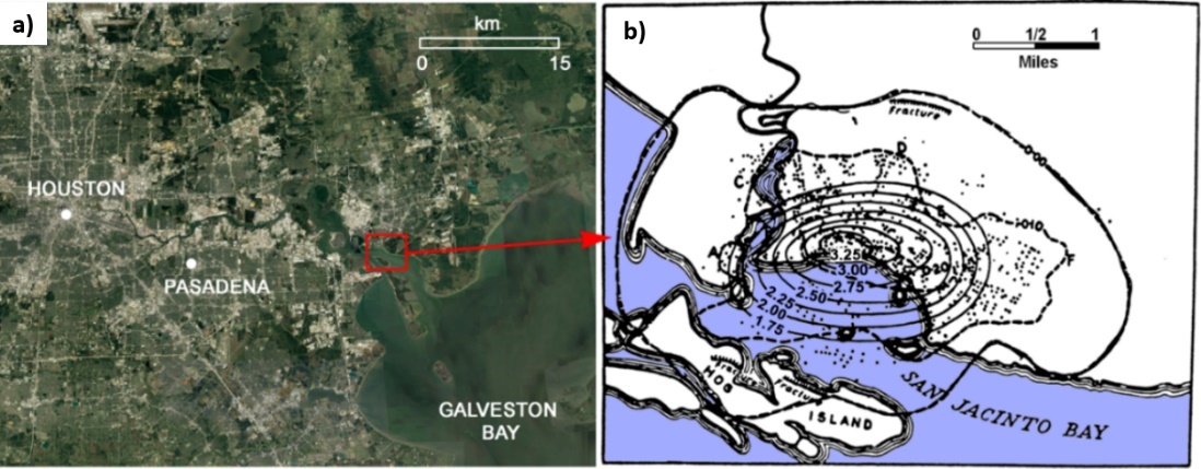
Figure 7 ‑ a) Location of the Goose Creek mouth on the Galveston Bay close to Houston, Texas, USA. b) Land subsidence map (in feet, 100 feet is approximately 30.5 meters; 1 mile is approximately 1.6 kilometers) provided by Pratt and Johnson (1926).
Quantitatively speaking, the principle of effective intergranular stress advanced by Terzaghi (1923) showed soil consolidation as the primary cause of land settlement. Soon, this principle was recognized as being an active factor in the compaction of an aquifer (the Dakota Sandstone) (Meinzer and Hard, 1925), who stated that the overburden pressure of all beds above the confined Dakota aquifer was supported partly by the fluid pressure and partly by the sandstone itself, via the effective intergranular stress. They concluded that the grain‑to‑grain load had increased by about 50 percent because of the decline of artesian head. Based on both laboratory tests and field measurements, Meinzer (1928) cited evidence indicating the compressibility and elasticity of artesian aquifers. He recognized that water withdrawn from storage was released by compression of the aquifer and by expansion of the water, and that reduction of storage (compression) may be permanent (inelastic) as well as elastic.
Rappleye (1933) provided the first specific records of subsidence due to groundwater pumping in the Santa Clara Valley (California, USA), and Ingerson (1941) described the subsidence in the Delano‑Tulare‑Wasco (California, USA) area. He presented a map and profiles of land subsidence based on comparison between leveling surveys performed in 1902, 1930, and 1940. By this time the relationship between the removal of subsurface fluid (water, oil, gas) and land subsidence was recognized, at least in the USA.
Jacob (1940) postulated that when water is pumped out from an elastic artesian aquifer system and pore pressure is decreased. As a result, withdrawn water is derived from water expansion, aquifer compression, and compression of the adjacent and intervening clay beds. He stated that the third source is probably the chief one: ”because of the low permeability of the clays (or shales) there is a time lag between the lowering of pressure within the aquifer and the appearance of that part of water which is derived from storage in those clays (or shales)”. Subsequently Lohman (1961) developed an equation for determining the amount of elastic compression of artesian aquifers from known declines in artesian pressure and hydro‑mechanical properties of the aquifers. This compression was intended as being transferred to the ground surface, producing an estimate of the resulting land subsidence.
In the late fifties and sixties, the concept interrelating land subsidence and fluid withdrawal was universally accepted thanks to the fundamental contributions by Poland, a pioneer in anthropogenic land subsidence studies (Poland and Davis, 1969). Around the same time the principle of effective stress was universally recognized in geomechanics (Taylor, 1948; Terzaghi and Peck, 1948; Leonards, 1962). By the end of the sixties the concept and the mechanism underlying land subsidence of anthropogenic origin were clear. The way was open to new progress in the mathematical formulation of equations governing the process and corresponding solutions helpful in predicting expected land subsidence in exploited aquifer systems. A pioneering finite element model of the anthropogenic land subsidence of Venice is discussed by Gambolati and Freeze (1973) and Gambolati et al. (1974).

Figure 8 ‑ a) Fissuring and b) faulting due to deformation of aquifer systems accompanying groundwater pumping.
A second important geomechanical effect associated with groundwater pumping from unconsolidated sedimentary aquifer systems is ground rupture. The nature of ground failure may range from fissuring, that is, formation of an open crack, to faulting, that is, differential offset of the opposite sides of the failure plane (Figure 8).
Ground ruptures associated with land subsidence were first observed in 1949, in central Arizona, by Feth (1951). In the wake of this pioneering work, it would take more than 20 years for the United States Geological Survey to undertake major investigations examining earth fissures in subsiding areas of the southwestern United States (California, Arizona, Texas, and Nevada). Holzer and Pampeyan (1981) recognized that ”the areal and temporal association of earth fissures with land subsidence caused by groundwater withdrawal indicated that these fissures were man induced”. The underlying mechanism was highlighted at that time, as soon as enough field data became available to test the hypothesis. Bending caused by localized differential displacements was originally proposed by Feth (1951) to explain the observed fissuring. He speculated that it might have been caused by extensional strains generated by locally varying degrees of subsidence. He attributed the differential subsidence to abrupt variations in aquifer thickness. Lofgren (1971) suggested that horizontal displacements measured in subsiding areas might be due to horizontal seepage forces. Based on the association of earth fissures with water table decline and other field evidence suggesting fissures formed at depth and propagated upward, Holzer and Davis (1976) held that fissures were caused by desiccation due to water table lowering. Over the last decade, the availability of three‑dimensional geomechanical models has allowed for preliminary attempts at simulating ground ruptures as they relate to anthropogenic alterations in the porous medium stress state. Modeling suggests that primary controls are reactivation of a preexisting fault, differential compaction due to variations in thickness of aquifer/aquitard layers constituting the aquifer system, and tensile fracturing above bedrock ridges that form the base of the aquifer system.