7.1 Groundwater as a Hydrologic Regulator
The relative sizes of Earth’s water reservoirs are shown in Figure 46. The largest bubble shows the volume of all the liquid water on the surface, under the surface, and in the atmosphere of Earth relative to the total size of the planet (Figure 46a). Only 2.5% of that water is fresh and most terrestrial life depends on that fresh water. Of the total fresh water on Earth, about 70% is locked up in polar ice inaccessible to terrestrial life (Figure 46b). The 99:1 relative size of groundwater to surface waters has great significance. Using the bank analogy that was presented earlier, the ready cash flow (surface water) is only 1% of the bank balance. This is good news for hydrologic “financial” security, because streams, lakes, wetlands, and all life that depends on them, has reserve funds available in the groundwater reservoir. That is, surface waters will not go dry if the rain stops for a while because the large groundwater reservoir keeps discharging water into them as baseflow. In this sense, by its sheer volume the fresh groundwater reservoir serves as a buffer to maintain rivers and wetlands through variations of weather and climate. However, when we change the landscape to allow more water to run to the oceans and less to recharge groundwater (for example through deforestation, urbanization, or heavily irrigated agriculture) there is less groundwater to support the fresh water cycle.

As discussed earlier, the groundwater levels are not only impacted by variations in weather and climate, but also by humans pumping water from wells. Again, the groundwater reservoir’s vast size and capacity to store water provides a buffer when water levels are lowered by pumping wells, because water is first drawn from groundwater storage, due to lowering of the water table as water flows to the well, before it decreases groundwater flow to streams, or draws water from streams. In addition, in some areas, the lowered water table decreases the amount of evapotranspiration (Figure 47), thus enhancing recharge to support groundwater discharge to wells and as baseflow to streams. This is yet another way that the groundwater system buffers surface water flows. Of course, new water is not created, so vegetation dependent on that evapotranspiration will die and be replaced by plants that require less water, and surface water bodies in the area of the lowered water table may decrease in size or go dry. In effect, water is “stolen” from other portions of the hydrologic cycle.

Around the globe, continual decline of groundwater levels indicates groundwater is being pumped more rapidly than it is being recharged. Groundwater depletion is estimated to be on the order of 283 cubic kilometers (km3) per year plus or minus about 40 km3 (Wada, 2016) and this has global implications. When extraction of groundwater is larger than natural recharge, the volume of water on the Earth’s surface increases as the volume in the subsurface decreases. This increased volume of surface water as a result of over‑pumping has made a substantial contribution to sea level rise, contributing approximately 0.8 +/‑0.1 mm/year to ocean rise, which is about 25% of the current 3.1 mm/year rise of the oceans (Wood and Hyndman, 2018).
One example of extreme groundwater decline is found in the North China Plain (Zheng et al., 2010), an area of about 40,000 km2, where since the 1950s groundwater levels declined over 90 meters in some wells with a spatially averaged decline of 15 meters as the result of unsustainable groundwater pumping (Figure 48). The depressed water levels have resulted in dry streams and land subsidence.

Given that aquifer depletion throughout the world is reducing river baseflows and causing sea level rise, geoengineering interventions in the hydrologic cycle are being implemented in an attempt to reverse these negative impacts by managing water table elevation in some watersheds. Management requires less pumping, more groundwater recharge, or both. To achieve higher average recharge over a span of many years, more of the precipitation must reach the water table while less precipitation escapes as shallow runoff from the aquifer catchment. The specific procedure for enhancing recharge varies from place to place, but may include: landscape engineering to impede and capture runoff; infiltration of treated wastewater through engineered wetlands or spreading basins with permeable bottoms; and/or use of wells to inject storm water or treated wastewater into aquifers. Managed aquifer recharge programs are becoming more common for reduction of aquifer depletion because the alternative, which is less groundwater extraction, is so difficult to achieve in a world of increasing population accompanied by agricultural and industrial growth. However, such programs rely on available aquifer storage capacity and the only aquifers that offer much storage capacity are unconfined aquifers where the added water fills unsaturated pore space.
To achieve a sustainable groundwater supply, groundwater levels (and thus groundwater storage) may fluctuate substantially from year to year, but the average must be constant over the long term. In wet years, the groundwater reservoir receives more recharge, so its storage is replenished. This can balance the depletion of water from storage in dry years, if the long‑term average rate of pumping is managed properly over many years (or decades) to accommodate the long‑term cycle of droughts.
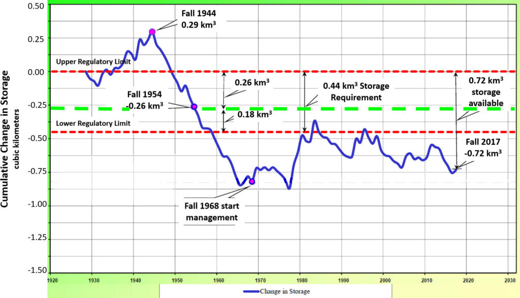
One example of such management was implemented in 1968 in an effort to halt the groundwater overdraft in the San Fernando Basin which provides drinking water for the city of Los Angeles, California, in the United States. Water levels had been measured since 1929 and were used to estimate the amount of water stored in the aquifers of the basin (Figure 49). Development caused declining water table elevations from 1945 into the 1960s, this large depletion of groundwater storage prompted the management plan. The plan requires approximately 0.44 km3 of groundwater to be stored in the aquifer (green dashed line of Figure 49). To account for wet and dry periods, it was specified that the minimum storage could be as much as 0.18 km3 less than the required storage (lower red dashed line of Figure 49) to provide storage space for adding water to the aquifer in wet years. The maximum storage could be as much as 0.26 km3 more than the required storage (upper red dashed line of Figure 49) to prevent water levels rising to the point that groundwater would be lost through discharge to adjacent groundwater basins. As shown in Figure 49, with only a few brief exceptions, the amount of storage has rarely fallen in the targeted range. However, the depletion has stopped, and the community continues to develop recharge facilities to increase the amount of water that can be added to the system.
Stored groundwater represents “savings” put into the “bank” by nature over a profoundly long period of time. But, like fossil fuels, we are “withdrawing” and “spending” that long‑term savings over an extremely short period relative to the time required to put the water into storage. In many agricultural regions of the world, water that resided in aquifers for tens of thousands of years has been depleted within the last half century. Such “spending” of long‑term reserves, be it ancient groundwater that entered the subsurface tens‑of‑thousands of years ago, or coal beds and petroleum reservoirs that were formed by ancient plants buried hundreds‑of‑millions of years ago, means that we continually leave less of these resources to future generations.