Occurrence of Salty, Mineral-rich Groundwater
Salty groundwater is common in all deep groundwater zones. Fresh groundwater is the norm for shallow zones, although salty groundwater is common in shallow zones of arid climates.
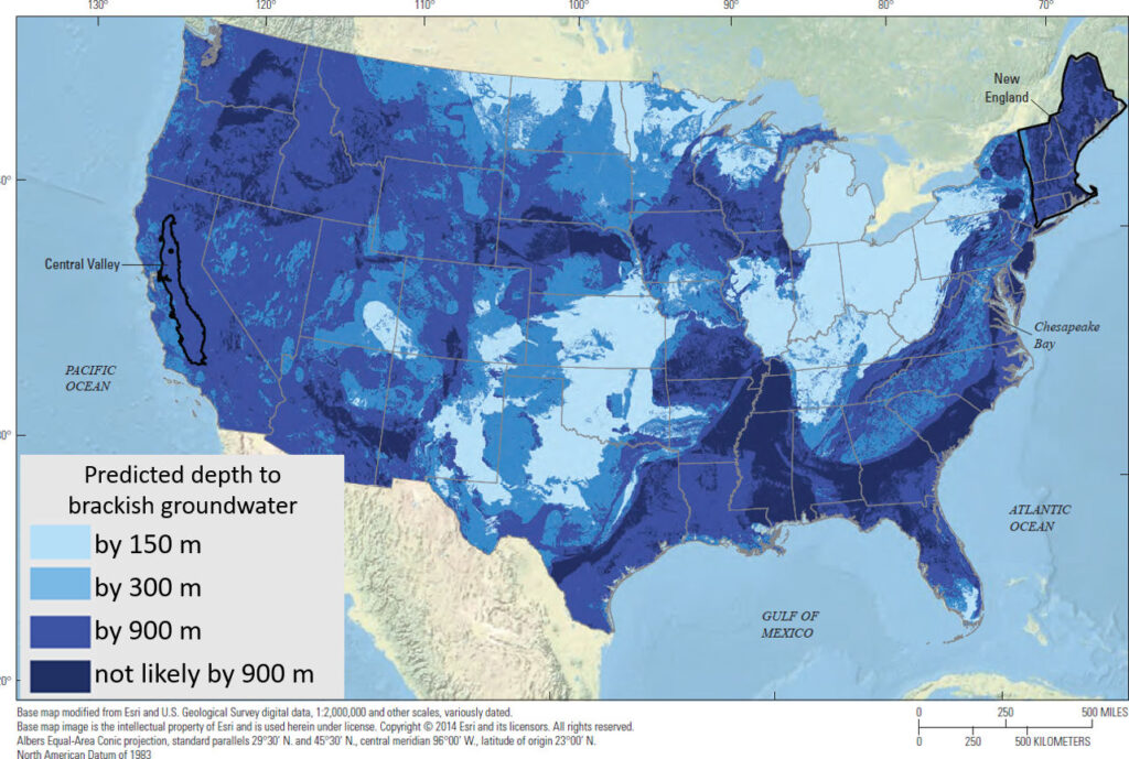
After the flushing of relic chloride over long periods of geologic time, today’s shallow fresh water zone extends to substantial depth around the globe as a result of eons of groundwater flushing. There are many regions where groundwater is fresh to depths of 500 meters or more (Bierkens and Wada, 2019). Below these depths, groundwater is most likely brackish of saltier. The depth of the bottom of the fresh water zone (i.e. to the top of the brackish water zones) varies greatly around the globe. To illustrate this, the estimated depth to brackish water in the continental United States is shown in Figure 57.
Unanticipated occurrences of fossil freshwater have been discovered under the ocean floor off the northeast coast of the United States. This indicates that much remains to be discovered about the extent and character of groundwater in some areas of the globe (Gustafson et al., 2019).
Where the groundwater flow system discharges to the surface, the chemical constituents end their groundwater journey and enter the above‑ground portion of the hydrologic cycle. In regions with a humid climate, this journey ends as seepage into streams, rivers, wetlands and lakes, ultimately reaching the oceans. In arid and semi‑arid regions, the journey ends as seepage to lowland flats and dry valleys. Evaporation from such areas can concentrate the solutes in shallow groundwater by hundreds to thousands of times, leaving the areas unsuitable for agriculture. In short, the chemistry of the groundwater discharge governs both the chemistry of most surface waters and the accumulations of salts on land and in soils of arid regions.
In arid climates vegetation is sparse, recharge is minimal, water tables are generally deeper, hydraulic gradients are low, and groundwater residence times are long. As a result, the dissolved constituents in groundwater of arid areas differ from, and concentrations are generally higher than, those where groundwater recharges in humid areas and flushes the geologic units. Most constituents in groundwater originating in arid climates are from atmospheric aerosols that are concentrated by evaporation and accumulate on the surface until a rare, major recharge event flushes them down to the water table. The lack of vegetation reduces the amount of carbon dioxide in the recharge zone; thus, chemical weathering of the aquifer material by carbonic acid is slower and concentrations of constituents produced by chemical weathering are lower. As a result, the groundwater includes more sodium chloride, calcium sulfate or sodium carbonate and less calcium carbonate than groundwater originating in humid zones. In addition to these differences, the slower groundwater flow allows time for constituents from relic and underlying saline aquifers to migrate into the shallow groundwater system, further increasing its salinity.
In some arid places where groundwater discharges to the surface, open water is not visible; instead the water evaporates at the surface and salt deposits form. This occurs in many places on Earth. A study of the Abu Dhabi salt flats illustrates water evaporating from the capillary fringe that intersects the surface forming a salt flat covering about 36,000 km2 (Figure 58). Much of the dissolved chemical constituents originate from groundwater seeping to the surface creating a concentration that is about 10 times that of sea water. The sparse, or absent, vegetation in arid areas permits aeolian (wind) processes to act in concert with the water table to develop unique landforms such as sabkhas (Arabic, for salt flats). With minimal vegetation, aeolian activity erodes deeply into the surficial sediments, but cannot move material below the capillary zone, as it is fully saturated, and thus not lifted by the wind. In such a place, the Earth’s surface reflects the shape and slope of the underlying water table. These surfaces then become large, flat, discharge areas where evaporation causes salt accumulations that form salty crusts (Figure 58).

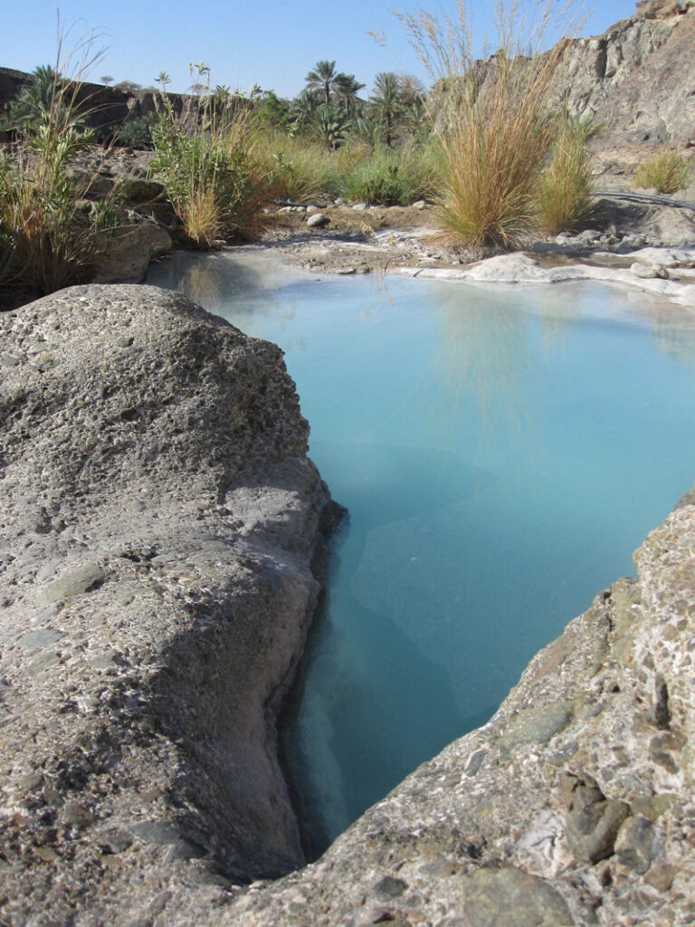
Alkaline (high pH) springs sometimes referred to as “Blue Pools” because of their deep blue color, are found in areas where high temperature minerals from the Earth’s mantle have been brought near the surface by tectonic activity of the Earth (Figure 59). These minerals were formed at high temperature and pressure and are unstable in the near surface environment, thus are easily weathered. Weathering, in this case without carbon dioxide, involves splitting of water molecules with removal of a hydrogen ion (H+) to form silicic acid (H4SiO4) and hydroxide ions (OH–) that increase the alkalinity (i.e. raise the pH). When the water is discharged to the surface, the calcium ions in this alkaline water react with carbon dioxide in the atmosphere and the mineral calcite (CaCO3) precipitates in very thin sheets on the water surface. These sheets then sink to the bottom of the pool forming a soft, fluffy white sediment. The pools are blue because water absorbs the red part of the light spectrum leaving colors in the blue part of the light spectrum for our eyes to see, and this effect is enhanced by the shallow water overlying the white calcium carbonate bottom. In many such pools inorganic methane and hydrogen gas bubbles can be observed rising to the surface.