2 Defining Groundwater
Groundwater is water that occurs below the ground surface in zones of porous materials where all the cracks (fractures) and pore spaces are filled with water and that water is at a pressure higher than the pressure of the atmosphere (Figure 1). This region or zone is referred to as the zone of saturation, saturated zone, zone of phreatic water, or groundwater zone.
The top of the groundwater zone is represented by the water table which is defined as the level or elevation where the water pressure is equal to atmospheric pressure. Above the water table, water pressure is less than atmospheric pressure, and below the water table, water pressure is greater than atmospheric pressure. Some literature refers to all water below the land surface as groundwater, however; in the scientific literature groundwater is clearly defined as the water occurring in the saturated zone and this is how it is used here.
Between the land surface and the water table the fractures and pore spaces contain both air and water. This region is called the zone of aeration, unsaturated zone, or vadose zone. This book uses both vadose zone and unsaturated zone to describe the region above the water table. The term unsaturated zone is commonly used even though as soil water moves downward through the vadose zone towards the water table, portions of the zone can become saturated temporarily and later return to unsaturated conditions. Just above the water table, fractures and pores are completely filled with water at a pressure that is less than atmospheric and so, by definition, it is part of the vadose zone. This part of the vadose zone is called the capillary fringe indicating its unique nature (full saturation at less than atmospheric pressure). The capillary force can “pull” water upward, against gravity, much like a dry sponge soaking up spilled water on a kitchen countertop. The capillary fringe extends a few millimeters above the water table in large pores such as occur in gravel deposits and large fractures, tenths of a meter to a half-meter in sands, and multiple meters in silts and clays (Todd and Mays, 2004).

In contrast to the saturated zone, the water in the vadose zone is at less than atmospheric pressure as reflected by a negative pressure on a gauge that uses atmospheric pressure as the reference point. The negative pressures are due to capillary forces that result from the adhesion of water molecules to subsurface solids and the cohesion of water molecules to one another. The negative pressures vary depending on the amount of moisture in the soil (Figure 2). As the amount of water in the vadose zone increases the tensional forces decrease (pressure becomes less negative) enough for gravity to pull water downward to the water table and recharge the groundwater system.
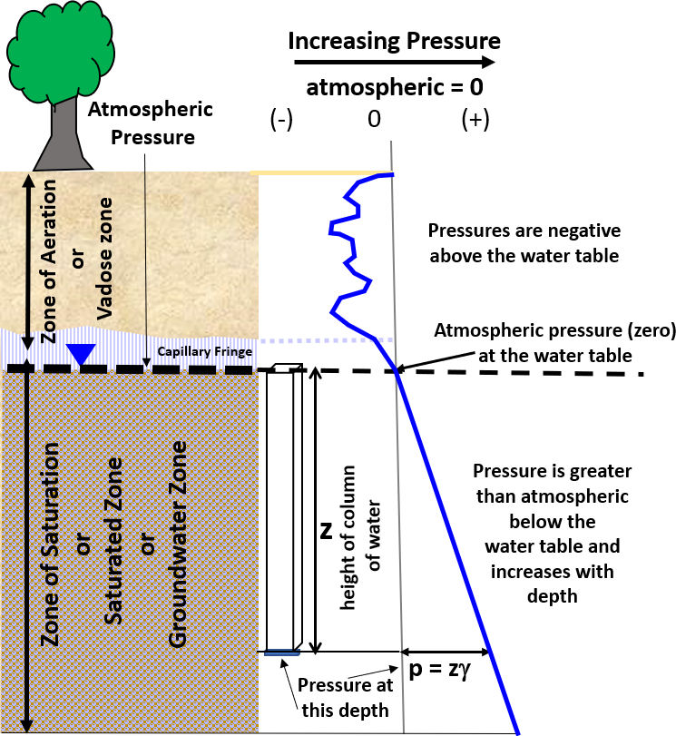
The top of the zone of saturation is the water table. The water in the saturated zone at a particular depth below the water table is a combination of the atmosphere bearing down on the water table (zero on a gauge that uses atmospheric pressure as a reference pressure) and the pressure caused by the weight of water in the column between the water table and the depth of interest (pressure, p, in Equation 1 as shown in Figure 2). Specific weight, γ, is density of a substance times the gravitational constant, ρg.
| p = z γ | (1) |
where:
| p | = | pressure at the base of a column of water below the water table (F/L2), which is force (i.e., weight) per unit area |
| z | = | height of the column of water (depth below water table) (L) |
| γ | = | specific weight of the water (F/L3) |
In the saturated zone, groundwater movement is primarily lateral. Gravity drives flow through interconnected pores and fractures from areas of higher groundwater levels (elevations) to areas of lower water levels. Groundwater in the saturated zone can be extracted by wells, flow to surface water bodies such as lakes and rivers, transport contaminants, and provide water for cities, agriculture and industry.