
17.3 Alluvium
Alluvium refers to sediments deposited by running water. These include gravel in a stream channel, sand deposited on a riverbank, and the mud that is deposited outside of the river channel during a flood. Alluvial systems are often excellent aquifers. The natural sorting of sediments by flowing water often results in continuous deposits of coarse sediments that have high permeability and porosity. There are three basic types of alluvial deposits that we will consider here: alluvial fans, deltas, and floodplain/river valley deposits.
Alluvial Fans
Sediment transport in a stream is controlled by the energy of the stream—highly energetic streams in mountainous areas can carry lots of large grains, while slower streams with flatter stream gradients carry finer sediments. Whenever the gradient—and therefore, the energy—of a stream suddenly decreases, much of the sediments carried by the stream drop out of the water and settle on the surface. This occurs when a stream flows out of a mountainous area on to a flat plain, leaving behind a large pile of sediment called an alluvial fan (Figure 135 and Figure 136).
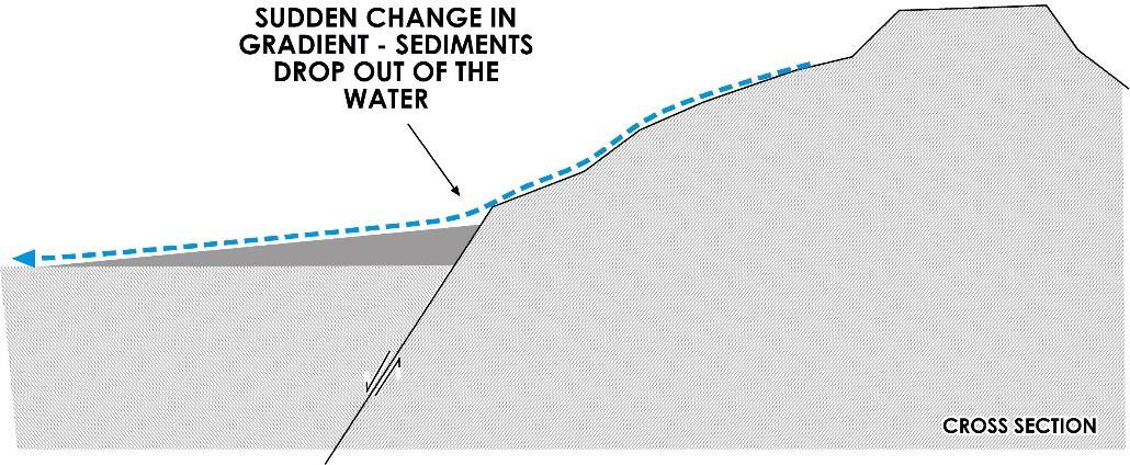
Figure 135 ‑ Cross section of an alluvial fan (dark gray) developing at the foot of a fault‑block mountain range where an abrupt change in the stream (dashed blue line) gradient causes rapid deposition of coarse sediment.
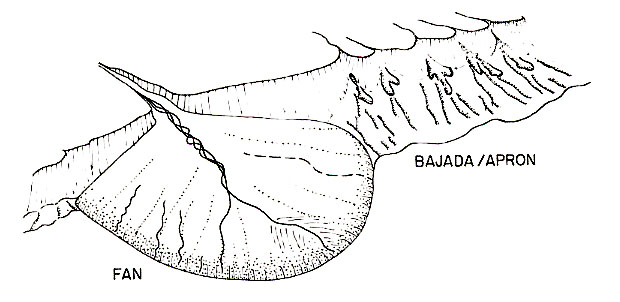
Figure 136 ‑ Aerial view of a single alluvial fan adjacent to a bajada or alluvial apron (reproduced from Galloway & Hobday, 1996).
Streams flowing out onto alluvial fans tend to carry a wide variety of sediments that range from mud and silt to sand to coarse gravel. The changes in stream energy across the fan results in sorting of sediments so that coarser sediments are located near the proximal end—that is, near the mountain—and finer sediments are near the distal end. Because of this, the most productive wells will generally be found near the break in slope at the foot of the mountains. The sediments in an alluvial fan are generally unconsolidated, although in arid regions, extensive evaporation can cause mineral precipitation that partially cements the sediments. Also, evaporation can leave behind caliche, which is a layer of fairly hard calcium carbonate deposited in the soil zone that can inhibit infiltration of water into the sediments.
Sometimes a series of alluvial fans will coalesce into a large package of sediments called a bajada, or alluvial apron (Figure 136). In fault‑block mountain areas like New Mexico and Nevada in the US, entire valleys can be filled with alluvial fan sediments to depths of as much as 1,000 meters.
Groundwater systems in alluvial fans are usually unconfined and receive much of their recharge from infiltration of precipitation and inflow of water from losing streams. Sometimes interbedded sands and clays result in locally confined units. Groundwater flow is usually controlled by the topography. Streams near the proximal end are usually losing flow to the aquifers, while the distal end of the fans often contain springs and gaining streams. These systems usually have very little fine sediments in them, because the finer sediments tend to get carried away by streams, so permeabilities are often high.
Alluvial‑filled, fault‑block valleys often contain significant regional‑scale groundwater flow systems (Figure 137).
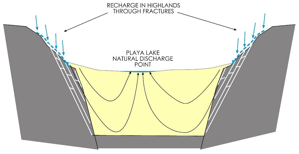
Figure 137 ‑ Cross section of alluvial‑filled, fault‑block valley and groundwater flow system. Solid blue arrows represent recharge, dashed blue arrows represent streams that deposit and recharge alluvial fans, curved black arrows represent groundwater flow paths.
In arid regions, much of the alluvium includes a shallow layer of caliche that inhibits infiltration of precipitation. Also, high evapotranspiration rates cause most of the precipitation on the valley floor to be utilized before it reaches the water table. Usually, recharge in these arid systems is primarily through fractures in the bedrock exposed in the highlands, which then convey water to the unconsolidated alluvium. The groundwater system flows toward the middle, with eventual discharge to shallow lakes in the center of the valley called playa lakes. In some places, groundwater discharges directly into the lake, and then flows out of the valley on the surface. In many arid and semi‑arid regions, the lakes are usually dry, and the primary mode of discharge is through evaporation directly from the water table below the playa, which results in highly saline groundwater just below the playa and extensive deposits of salt at the surface called salt flats.
Alluvial fans are often important sources of water in arid and semi‑arid regions because the lack of thick vegetation in semi‑arid climates tends to result in much greater erosion and sedimentation. As a result, alluvial fans tend to be much larger in area and thicker. Less vegetation also results in less evapotranspiration, which in turn can increase infiltration and recharge. The lack of surface water in these areas generally means that groundwater is more crucial.
Deltas
Deltas are in many ways like alluvial fans, but they form where a stream enters a larger body of water, such as a lake, inland sea, gulf, or ocean. As the stream enters the larger body of water, water velocity—and related fluid energy—abruptly decreases drastically, which results in the stream depositing much of its sediment load. A major difference between alluvial fans and deltas is that deltas contain much more fine‑grained material. This is because, in alluvial fans, the water energy of the stream leaving the depositional area of the fan is still sufficient to carry away most of the fine‑grained material, while the typical delta has low fluid energy with coarse‑grained sediments deposited only in localized areas.
Deltas can be classified based on their shape, which is directly related to the forces that control deposition and ultimately geometry. Deltas are classified as fluvial‑dominated, wave‑dominated, or tide‑dominated, or usually some combination of these.
Fluvial-, or river-, dominated deltas (Figure 138) are deltas whose shape is controlled by the input of sediment. These form in locations where rivers flow into relatively low energy environments, typically an inland sea, or gulf. These are often called birds‑foot deltas because the streams tend to form relatively narrow linear piles of sediment that extend out into the bay or ocean that are similar to the shape of a bird‘s foot. The Mississippi River delta on the Gulf Coast of Louisiana in the USA is an example of a fluvially‑dominated delta.
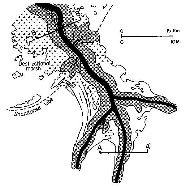
Figure 138 ‑ Map showing a hypothetical example of a fluvial‑dominated delta (reproduced from Galloway & Hobday, 1996).
Wave‑dominated deltas (Figure 139) form where rivers drain into bodies of water with relatively high wave action. The shape of the delta is affected by the waves so that the delta front is smoothed out. Wave action also results in a lot of re‑working of the sediments in the delta front, which in turn results in removal of fine sediment and sorting of the sand fractions. An example of a wave‑dominated delta is the Nile River delta in Egypt.
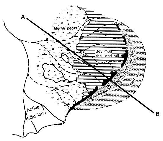
Figure 139 ‑ Map showing an example of a hypothetical wave‑dominated delta (reproduced from Galloway & Hobday, 1996).
Tide‑dominated deltas (Figure 140) are like wave‑dominated deltas in that tidal fluctuations are extensive reworking the sediments and the shape of the delta front. In contrast to wave-dominated deltas, in tide‑dominated deltas; the energy is usually perpendicular to the wave front. Whereas wave action creates a longshore drift that moves sediment parallel to the front, the daily movement of tides perpendicular to the coastline reworks the sediments to create lobes of sediment perpendicular to the delta front. An example of a tide‑dominated delta is along the coast of Bangladesh where numerous river systems drain into the Bay of Bengal.
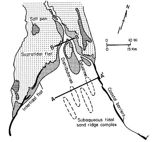
Figure 140 ‑ Map showing an example of a hypothetical tide‑dominated delta (reproduced from Galloway & Hobday, 1996).
In active fluvial‑dominated deltas, coarse‑grained deposits are generally in abandoned stream channels. These channels are usually surrounded by mud and are isolated from each other. Therefore, the success of wells drilled into delta sediments depends upon penetrating a channel deposit of sufficient size. In wave or tide‑dominated deltas, the delta fronts will be very sandy and will contain lots of water, but that water is often non‑potable sea water.
In general, active deltas are usually not very good sources of potable water. Permeable units are too few and far between, and the groundwater is usually too salty to drink or contains too much organic material from swamps and tidal flat areas. Exceptions do occur; the Nile River Delta is generally very permeable, and the groundwater is clean enough to drink. However, high concentrations of manganese and iron causes steel well screens in the Nile Delta to clog with rust and manganese oxides; usually these wells only last a few years before they must be replaced.
Floodplain/river Valley Deposits
The area around rivers can contain very productive aquifers, and these areas have historically been extensively used as a source of water for irrigation and drinking. River valleys usually contain unconsolidated, high‑permeability, coarse-grained, channel deposits interspersed with finer grained floodplain deposits. They are usually shallow and easy to drill. They are connected to surface streams, have a fairly constant source of recharge, and usually have fairly good water quality. In larger rivers, these deposits can be up to 50 meters thick with a significant saturated thickness.
In addition to current river valley deposits, floodplain and channel deposits from ancient rivers can often be found in glaciated areas or in deserts. In the Sahara Desert of Africa, for example, ground‑penetrating radar has identified an extensive system of river valleys, buried beneath the sand, that contain vast groundwater reserves. Another example is the Ogallala aquifer in the High Plains of the US, which is an extensive fluvial system that formed as the Rocky Mountains were uplifted in the west. This network of streams left behind extensive deposits of sands and silt that make up one of the largest and most prolific aquifers in the world.