
1.4 Groundwater
The strict technical definition of groundwater is any water that is found beneath the surface of the Earth. This definition includes:
- moisture that is found in the pores between soil grains;
- fresh to slightly saline water, found in saturated geologic units near the surface, which is used for drinking and irrigation;
- extremely salty brines associated with petroleum deposits and deep sedimentary units; and,
- water found in the lower lithosphere and in the mantle.
In this book, we are primarily concerned with (b), fresh to slightly saline water that is found near the surface and that is frequently used for domestic, agricultural, and industrial purposes. From this point on, when the book uses the term groundwater, it is referring to the water described by definition (b).
Distribution of Water in the Subsurface
Several terms, such as porosity, permeability, and aquifer, are introduced in this section and defined in a general way. These terms are discussed in much more detail in later sections. Readers are encouraged to also review the Glossary of Hydrogeology↗ by Sharp (2023) and Hydrogeologic Properties of Earth Materials and Principles of Groundwater Flow↗ by Woessner and Poeter (2020); both books are available as free downloads from The Groundwater Project.
Geologic materials (i.e., rock, soil, and sediment) always have some amount of empty space in them. This empty space is called pore space, and the percentage of pore space by volume in a rock or sediment is called the porosity. Within all naturally occurring geologic units, the pore space always contains some amount of moisture.
Below the surface of the Earth, the sediments and rock contain moisture; however, not all the pore space is full—that is, there is both air and moisture within the pore spaces. Just below the surface, the amount of moisture is small, and the amount of moisture tends to increase with depth. Eventually, the amount of moisture becomes so great that the pore space is completely filled with water and the soil or sediment is saturated (Figure 4).
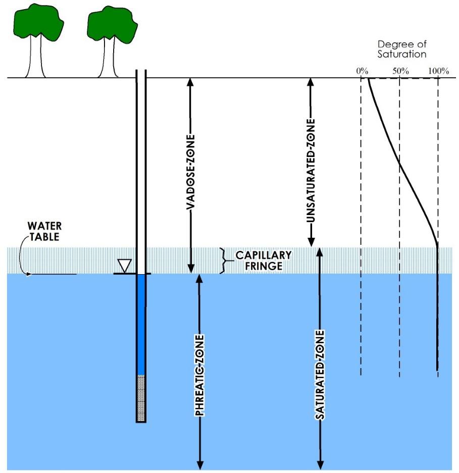
Figure 4 ‑ Cross‑section showing the distribution of water in the shallow subsurface.
Therefore, in the subsurface, we can distinguish between two basic zones: the unsaturated zone, and the saturated zone. The boundary between the two zones is often called the water table; in Section 14.2.2 the book it will be shown that the top of the saturated zone is not exactly at the same location as the water table.
Recharge and Discharge
As shown in Figure 3, groundwater is a part of the dynamic hydrologic cycle, and water must somehow enter as well as leave the subsurface. Water entering the subsurface is called infiltration—percolation of surface water (from rain, perennial streams, melting snow, urinating dogs, and so on) downward into the soil. As the water percolates down through the soil, sediment, and rock, the percentage of the pore space that is filled with water (or the degree of saturation) increases until it reaches 100 percent (i.e., complete saturation). Once this water reaches the saturated zone, it is called recharge.
Just as water enters the saturated zone, it must eventually leave it. Movement of water out of the saturated zone is called discharge. Natural discharge can be through a spring, into the bed of a stream, lake, or ocean, or via evaporation directly from the water table. Pumping of groundwater through wells—holes drilled into the ground for the purpose of accessing subsurface fluids—is another way that water discharges from the saturated zone.
Groundwater Flow
Groundwater is always flowing, and the direction of flow is determined by the location of higher groundwater elevation. It is important to recognize that groundwater does not flow downhill; rather, it flows from higher hydraulic head (or higher water level elevation) to lower hydraulic head. We discuss hydraulic head in more detail in subsequent sections. Additional information can be found in Conceptual and Visual Understanding of Hydraulic Head and Groundwater Flow↗ by Cohen and Cherry (2020), which is available from The Groundwater Project as a free download or can be read online. The distribution of hydraulic heads in the saturated zone determines the direction in which the water will flow.
The speed with which groundwater flows, called the velocity or flux, is determined by the difference in hydraulic head and the permeability of the sediment or rock through which it flows.
Permeability is a number that describes the ease with which a fluid (like water) will move through a porous medium—that is, a rock, soil, or sediment that has enough pore space to allow water to move through it. In Section 3, it is shown how the difference in head from one point to the next, and the permeability, can be used to estimate how quickly groundwater moves. More information can be found in Groundwater Velocity↗ by Devlin (2020) and in Section 4 of Hydrogeologic Properties of Earth Materials and Principles of Groundwater Flow↗ by Woessner and Poeter (2020); both books are available from The Groundwater Project as a free download or can be read online.
Aquifers
An aquifer is a geologic unit that can store and transmit enough water to supply a well and/or spring. The factors that determine if a geologic unit can be called an aquifer include the following.
- The permeability must be high enough that flow can be maintained at the required rates.
- The aquifer dimensions must be great enough—that is, there must be a significant saturated thickness—to supply water to a well.
- The quality of the water must be good enough for the intended use.
There are three basic types of aquifers: unconfined, confined, and perched as shown in Figure 5. Understanding the difference between unconfined and confined aquifers requires an understanding of hydraulic head and the storage characteristics of aquifer materials. In the Section 2, we introduce the concept of hydraulic head in detail and lay the groundwork for a quantitative understanding of groundwater storage and fluid flow in the subsurface. This is also discussed in Groundwater Storage in Confined Aquifers↗ by Wang (2020), which is available from The Groundwater Project as a free download or can be read online.
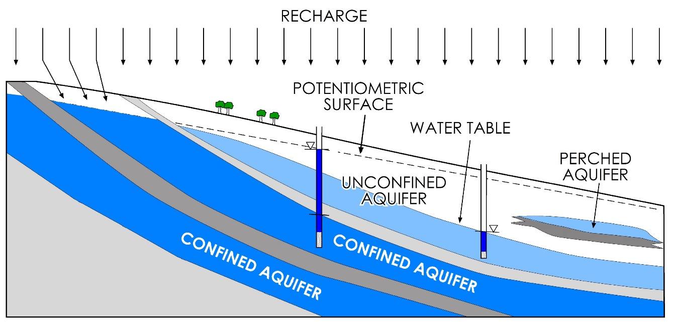
Figure 5 – Cross‑section showing various types of aquifers. The arrows represent precipitation; the bent arrows at the upper left of the diagram represent infiltration of precipitation ultimately recharging the uppermost confined aquifer. All the straight arrows to the right of those represent precipitation recharging the unconfined and perched aquifers.