
14.5 Studying the Unsaturated Zone: Instruments and Techniques
This section contains basic descriptions of a few instruments and techniques used to investigate hydrologic processes in the unsaturated zone. This is by no means a comprehensive list.
Tensiometers are used to measure matric head, or soil suction (Figure 113). These can be installed at varying depths to infer moisture profiles. Usually these are installed between 15 cm and 1 meter below the surface. Unlike the saturated zone, it is not possible to measure a water level in a piezometer in the unsaturated zone because water will not flow into the well. Instead, tension in the soil is measured and then added to elevation to get total head (Equation (7)).
A lysimeter is like a tensiometer, but instead of measuring matric potential it is used for sampling the moisture in the pore spaces of the soil so the water can be analyzed for its chemical content. A lysimeter has a tube and a porous cup like the tensiometer; however, the tube is left empty, and a partial vacuum is generated in the tube through a valve at the top. The ceramic cup is placed in the soil, and the vacuum in the tube draws water in from the soil, where it can be sampled via the sampling tube (Figure 117).
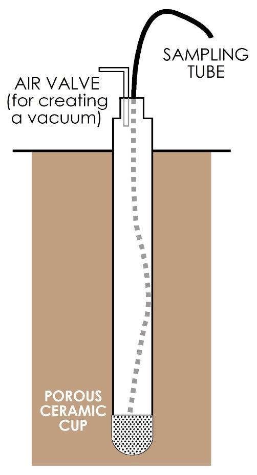
Figure 117 ‑ Lysimeter for vadose zone fluid sampling.
Gypsum blocks are small (1 to 2 cm) blocks of gypsum with embedded wires that can be hooked up to a box that measures electrical resistance. These are buried in the soil with the wires exposed. They can be used to indirectly measure soil moisture because gypsum is not very conductive and so, changes in moisture within the block are inversely proportional to changes in electrical resistance. These need to be replaced frequently (≈1 to 3 years).
Electrical permittivity sensors provide longer term monitoring using metal probes that are inserted into the soil. They are connected to a logger which sends an electrical signal and records a response relating the electrical permittivity to soil moisture. The logging interval is set by the user.
A common method for using tensiometers, lysimeters, and gypsum blocks is to set up a field experiment called an infiltration plot. In an infiltration plot, a plot of ground is isolated using wooden boards or a ring of sheet metal to create an enclosed area that can be filled with water to a certain depth. Instruments like those described above are installed within the infiltration plot at various depths and monitored for a period of time—for example, days, weeks—to record the initial conditions. The plot is then filled with water, and the instruments are monitored over the next few days as the water infiltrates into the ground. From this data one can develop a series of moisture profiles that illustrate movement of the wetting front down through the subsurface (Figure 118).
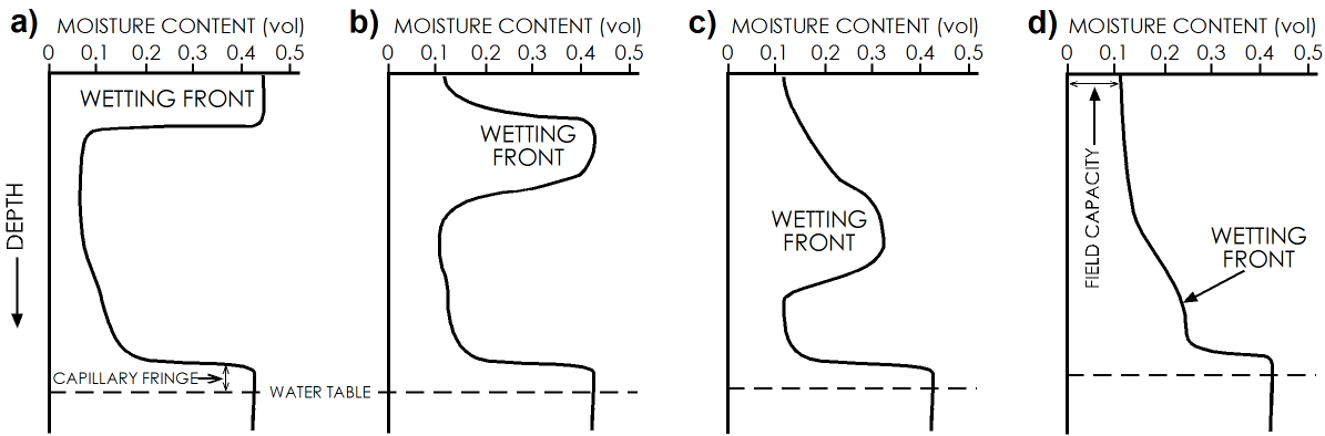
Figure 118 ‑ Moisture profiles showing the movement of a wetting front from an initial slug of water in an infiltration plot: a) initial infiltration saturates the shallow soil; b) with time the water percolates downward at varying rates such that the volume of water is spread vertically and the moisture content is less than full saturation; c) continued downward percolation increases the vertical spread of moisture and decreases the moisture contents; and d) some of the water introduced to the plot reaches, thus recharges, the water table causing a slight rise.